You are here: Home > Network List > TA - USArray Transportable Network (new EarthScope stations) Stations List
> Station Y26A Elida, NM, USA > Earthquake Result Viewer
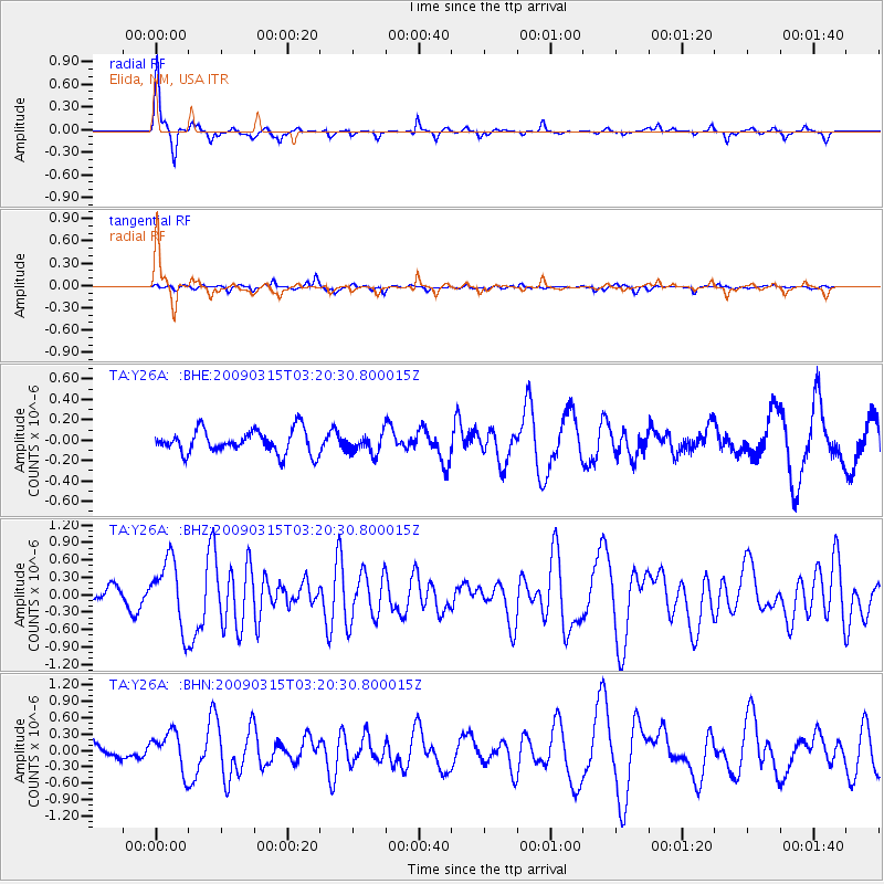
Y26A Elida, NM, USA - Earthquake Result Viewer

| Earthquake location: |
Galapagos Islands Region |
| Earthquake latitude/longitude: |
2.4/-95.1 |
| Earthquake time(UTC): |
2009/03/15 (074) 03:14:31 GMT |
| Earthquake Depth: |
10 km |
| Earthquake Magnitude: |
5.5 MS, 5.4 MB, 5.8 MW, 5.8 MW |
| Earthquake Catalog/Contributor: |
WHDF/NEIC |
|
| Network: |
TA USArray Transportable Network (new EarthScope stations) |
| Station: |
Y26A Elida, NM, USA |
| Lat/Lon: |
33.92 N/103.82 W |
| Elevation: |
1371 m |
|
| Distance: |
32.4 deg |
| Az: |
346.412 deg |
| Baz: |
163.603 deg |
| Ray Param: |
0.07868046 |
| Estimated Moho Depth: |
17.0 km |
| Estimated Crust Vp/Vs: |
1.61 |
| Assumed Crust Vp: |
6.129 km/s |
| Estimated Crust Vs: |
3.807 km/s |
| Estimated Crust Poisson's Ratio: |
0.19 |
|
| Radial Match: |
89.31919 % |
| Radial Bump: |
221 |
| Transverse Match: |
68.50419 % |
| Transverse Bump: |
383 |
| SOD ConfigId: |
2658 |
| Insert Time: |
2010-03-07 05:34:55.754 +0000 |
| GWidth: |
2.5 |
| Max Bumps: |
400 |
| Tol: |
0.001 |
|
Signal To Noise
| Channel | StoN | STA | LTA |
| TA:Y26A: :BHZ:20090315T03:20:30.800015Z | 4.4819007 | 5.799231E-7 | 1.2939223E-7 |
| TA:Y26A: :BHN:20090315T03:20:30.800015Z | 1.4363906 | 3.574851E-7 | 2.4887737E-7 |
| TA:Y26A: :BHE:20090315T03:20:30.800015Z | 0.8551176 | 9.8289064E-8 | 1.14942154E-7 |
| Arrivals |
| Ps | 1.8 SECOND |
| PpPs | 6.7 SECOND |
| PsPs/PpSs | 8.5 SECOND |


