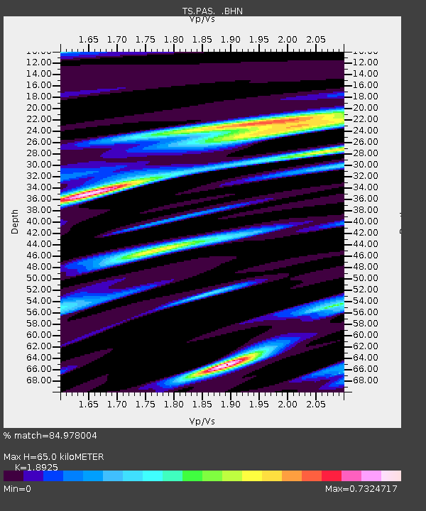
PAS Pasadena, California, USA - Earthquake Result Viewer
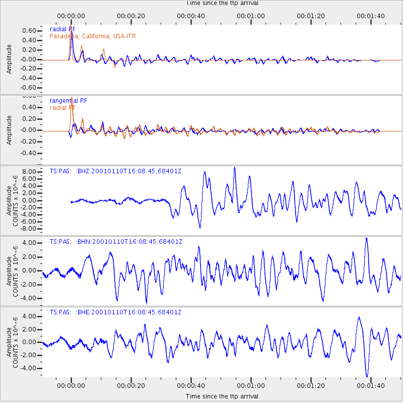
Earthquake location: Kodiak Island Region, Alaska
Earthquake latitude/longitude: 57.1/-153.2
Earthquake time(UTC): 2001/01/10 (010) 16:02:44 GMT
Earthquake Depth: 33 km
Earthquake Magnitude: 6.2 MB, 6.8 MS, 7.1 MW, 6.8 ML
Earthquake Catalog/Contributor: WHDF/NEIC
Network: TS TERRAscope (Southern California Seismic Network)
Station: PAS Pasadena, California, USA
Lat/Lon: 34.15 N/118.17 W
Elevation: 295 m
Distance: 33.0 deg
Az: 118.981 deg
Baz: 324.831 deg
Ray Param: 0.07836673
Estimated Moho Depth: 65.0 km
Estimated Crust Vp/Vs: 1.89
Assumed Crust Vp: 6.1 km/s
Estimated Crust Vs: 3.223 km/s
Estimated Crust Poisson's Ratio: 0.31
Radial Match: 84.978004 %
Radial Bump: 400
Transverse Match: 73.528244 %
Transverse Bump: 400
SOD ConfigId: 3744
Insert Time: 2010-02-26 14:33:17.265 +0000
GWidth: 2.5
Max Bumps: 400
Tol: 0.001

Signal To Noise

ChannelStoNSTALTA
TS:PAS: :BHN:20010110T16:08:45.68401Z2.1154166.4026295E-73.0266526E-7
TS:PAS: :BHE:20010110T16:08:45.68401Z1.06425574.5670131E-74.2912743E-7
TS:PAS: :BHZ:20010110T16:08:45.68401Z4.9181552.0172558E-64.1016514E-7
Arrivals
Ps10 SECOND
PpPs29 SECOND
PsPs/PpSs39 SECOND