You are here: Home > Network List > UW - Pacific Northwest Regional Seismic Network Stations List
> Station RADR Radar Ridge, Naselle, WA > Earthquake Result Viewer
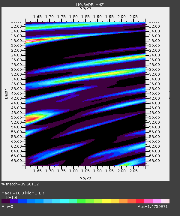
RADR Radar Ridge, Naselle, WA - Earthquake Result Viewer
| Earthquake location: |
Tonga Islands |
| Earthquake latitude/longitude: |
-18.4/-175.2 |
| Earthquake time(UTC): |
2019/11/04 (308) 22:43:37 GMT |
| Earthquake Depth: |
10 km |
| Earthquake Magnitude: |
6.9 Mi |
| Earthquake Catalog/Contributor: |
NEIC PDE/at |
|
| Network: |
UW Pacific Northwest Regional Seismic Network |
| Station: |
RADR Radar Ridge, Naselle, WA |
| Lat/Lon: |
46.42 N/123.80 W |
| Elevation: |
591 m |
|
| Distance: |
79.4 deg |
| Az: |
33.364 deg |
| Baz: |
229.012 deg |
| Ray Param: |
0.048957653 |
| Estimated Moho Depth: |
18.0 km |
| Estimated Crust Vp/Vs: |
1.60 |
| Assumed Crust Vp: |
6.566 km/s |
| Estimated Crust Vs: |
4.104 km/s |
| Estimated Crust Poisson's Ratio: |
0.18 |
|
| Radial Match: |
89.60132 % |
| Radial Bump: |
390 |
| Transverse Match: |
77.805084 % |
| Transverse Bump: |
400 |
| SOD ConfigId: |
19951751 |
| Insert Time: |
2019-11-18 23:02:17.711 +0000 |
| GWidth: |
2.5 |
| Max Bumps: |
400 |
| Tol: |
0.001 |
|

Signal To Noise
| Channel | StoN | STA | LTA |
| UW:RADR: :HHZ:20191104T22:55:12.000Z | 4.4174767 | 1.3710247E-6 | 3.1036376E-7 |
| UW:RADR: :HHN:20191104T22:55:12.000Z | 1.6807358 | 6.299189E-7 | 3.7478756E-7 |
| UW:RADR: :HHE:20191104T22:55:12.000Z | 1.0955179 | 4.756435E-7 | 4.3417225E-7 |
| Arrivals |
| Ps | 1.7 SECOND |
| PpPs | 6.9 SECOND |
| PsPs/PpSs | 8.6 SECOND |


