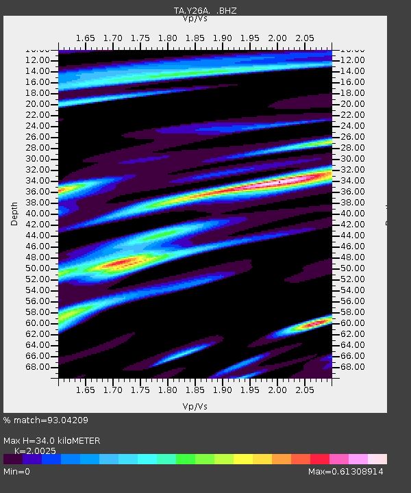
Y26A Elida, NM, USA - Earthquake Result Viewer
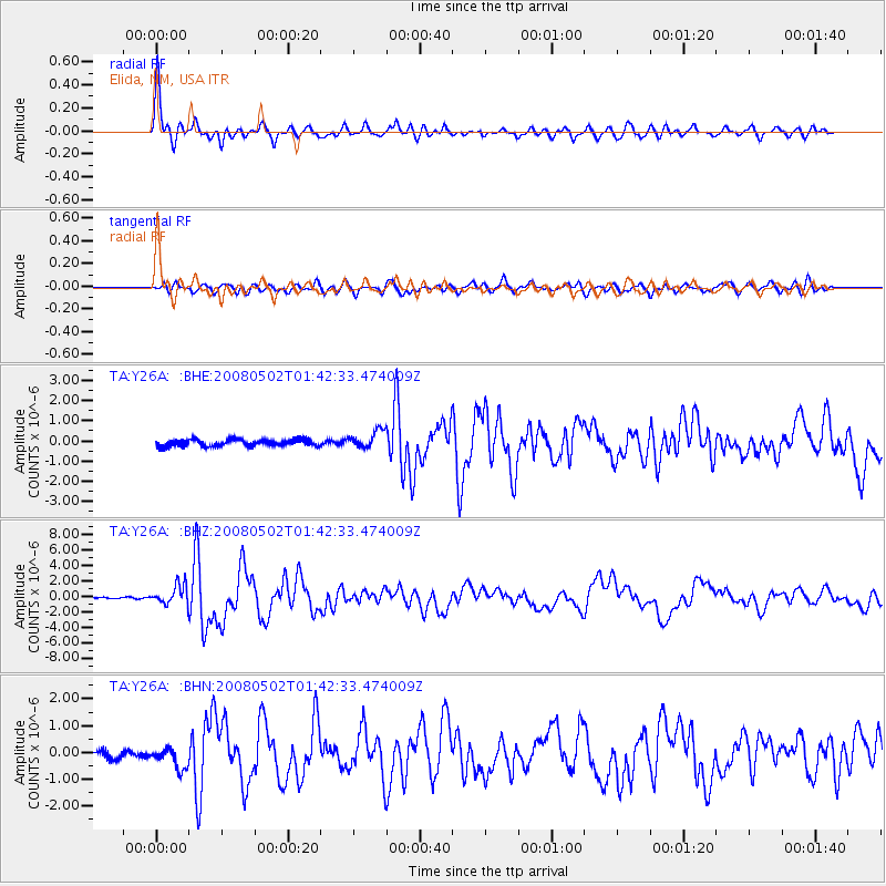
Earthquake location: Andreanof Islands, Aleutian Is.
Earthquake latitude/longitude: 51.9/-177.5
Earthquake time(UTC): 2008/05/02 (123) 01:33:37 GMT
Earthquake Depth: 14 km
Earthquake Magnitude: 6.3 MB, 6.8 MS, 6.6 MW, 6.6 MW
Earthquake Catalog/Contributor: WHDF/NEIC
Network: TA USArray Transportable Network (new EarthScope stations)
Station: Y26A Elida, NM, USA
Lat/Lon: 33.92 N/103.82 W
Elevation: 1371 m
Distance: 54.5 deg
Az: 78.567 deg
Baz: 313.035 deg
Ray Param: 0.06539077
Estimated Moho Depth: 34.0 km
Estimated Crust Vp/Vs: 2.00
Assumed Crust Vp: 6.129 km/s
Estimated Crust Vs: 3.061 km/s
Estimated Crust Poisson's Ratio: 0.33
Radial Match: 93.04209 %
Radial Bump: 400
Transverse Match: 82.15306 %
Transverse Bump: 400
SOD ConfigId: 2504
Insert Time: 2010-03-07 05:35:09.610 +0000
GWidth: 2.5
Max Bumps: 400
Tol: 0.001

Signal To Noise

ChannelStoNSTALTA
TA:Y26A: :BHZ:20080502T01:42:33.474009Z8.3706121.2534451E-61.4974354E-7
TA:Y26A: :BHN:20080502T01:42:33.474009Z3.50990564.015083E-71.14392904E-7
TA:Y26A: :BHE:20080502T01:42:33.474009Z2.70756444.4167152E-71.6312502E-7
Arrivals
Ps5.8 SECOND
PpPs16 SECOND
PsPs/PpSs22 SECOND