You are here: Home > Network List > IU - Global Seismograph Network (GSN - IRIS/USGS) Stations List
> Station RSSD Black Hills, South Dakota, USA > Earthquake Result Viewer
RSSD Black Hills, South Dakota, USA - Earthquake Result Viewer

| Earthquake location: |
Tonga Islands |
| Earthquake latitude/longitude: |
-18.7/-175.7 |
| Earthquake time(UTC): |
2019/11/04 (308) 22:46:10 GMT |
| Earthquake Depth: |
10 km |
| Earthquake Magnitude: |
5.5 mb |
| Earthquake Catalog/Contributor: |
NEIC PDE/us |
|
| Network: |
IU Global Seismograph Network (GSN - IRIS/USGS) |
| Station: |
RSSD Black Hills, South Dakota, USA |
| Lat/Lon: |
44.12 N/104.04 W |
| Elevation: |
2090 m |
|
| Distance: |
90.3 deg |
| Az: |
43.128 deg |
| Baz: |
244.154 deg |
| Ray Param: |
0.041681193 |
| Estimated Moho Depth: |
46.5 km |
| Estimated Crust Vp/Vs: |
1.60 |
| Assumed Crust Vp: |
6.242 km/s |
| Estimated Crust Vs: |
3.901 km/s |
| Estimated Crust Poisson's Ratio: |
0.18 |
|
| Radial Match: |
98.64308 % |
| Radial Bump: |
115 |
| Transverse Match: |
99.93114 % |
| Transverse Bump: |
16 |
| SOD ConfigId: |
19951751 |
| Insert Time: |
2019-11-18 23:05:40.900 +0000 |
| GWidth: |
2.5 |
| Max Bumps: |
400 |
| Tol: |
0.001 |
|
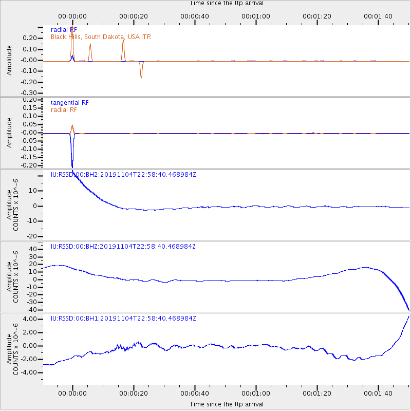
Signal To Noise
| Channel | StoN | STA | LTA |
| IU:RSSD:00:BHZ:20191104T22:58:40.468984Z | 0.8613742 | 6.115073E-5 | 7.099206E-5 |
| IU:RSSD:00:BH1:20191104T22:58:40.468984Z | 0.8148298 | 6.9363646E-6 | 8.512655E-6 |
| IU:RSSD:00:BH2:20191104T22:58:40.468984Z | 0.85349065 | 6.295889E-6 | 7.3766346E-6 |
| Arrivals |
| Ps | 4.6 SECOND |
| PpPs | 19 SECOND |
| PsPs/PpSs | 24 SECOND |


