You are here: Home > Network List > TS - TERRAscope (Southern California Seismic Network) Stations List
> Station PAS Pasadena, California, USA > Earthquake Result Viewer
PAS Pasadena, California, USA - Earthquake Result Viewer
| Earthquake location: |
Near Coast Of Guatemala |
| Earthquake latitude/longitude: |
13.9/-90.8 |
| Earthquake time(UTC): |
1999/06/06 (157) 07:08:05 GMT |
| Earthquake Depth: |
33 km |
| Earthquake Magnitude: |
5.5 MB, 5.9 MS, 6.3 MW, 5.8 MD |
| Earthquake Catalog/Contributor: |
WHDF/NEIC |
|
| Network: |
TS TERRAscope (Southern California Seismic Network) |
| Station: |
PAS Pasadena, California, USA |
| Lat/Lon: |
34.15 N/118.17 W |
| Elevation: |
295 m |
|
| Distance: |
32.0 deg |
| Az: |
313.866 deg |
| Baz: |
122.413 deg |
| Ray Param: |
0.07880204 |
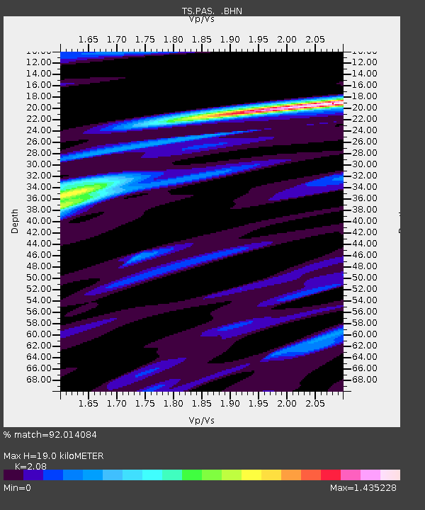
| Estimated Moho Depth: |
19.0 km |
| Estimated Crust Vp/Vs: |
2.08 |
| Assumed Crust Vp: |
6.1 km/s |
| Estimated Crust Vs: |
2.933 km/s |
| Estimated Crust Poisson's Ratio: |
0.35 |
|
| Radial Match: |
92.014084 % |
| Radial Bump: |
394 |
| Transverse Match: |
77.119446 % |
| Transverse Bump: |
400 |
| SOD ConfigId: |
4480 |
| Insert Time: |
2010-02-26 14:33:19.644 +0000 |
| GWidth: |
2.5 |
| Max Bumps: |
400 |
| Tol: |
0.001 |
|
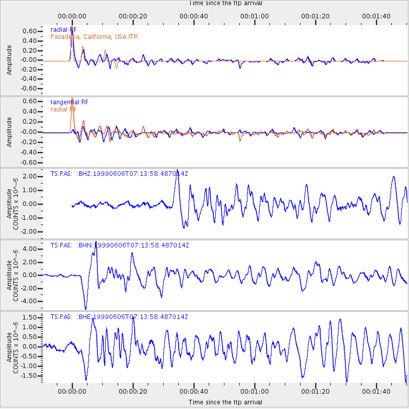
Signal To Noise
| Channel | StoN | STA | LTA |
| TS:PAS: :BHN:19990606T07:13:58.487014Z | 12.345239 | 2.0656132E-6 | 1.6732064E-7 |
| TS:PAS: :BHE:19990606T07:13:58.487014Z | 4.8606834 | 6.4361876E-7 | 1.3241323E-7 |
| TS:PAS: :BHZ:19990606T07:13:58.487014Z | 7.54626 | 9.561198E-7 | 1.2670115E-7 |
| Arrivals |
| Ps | 3.6 SECOND |
| PpPs | 9.0 SECOND |
| PsPs/PpSs | 13 SECOND |


