You are here: Home > Network List > TX - Texas Seismological Network Stations List
> Station HNDO Hondo > Earthquake Result Viewer
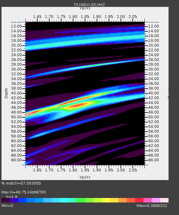
HNDO Hondo - Earthquake Result Viewer
| Earthquake location: |
Tonga Islands |
| Earthquake latitude/longitude: |
-18.7/-175.7 |
| Earthquake time(UTC): |
2019/11/04 (308) 22:46:10 GMT |
| Earthquake Depth: |
10 km |
| Earthquake Magnitude: |
5.5 mb |
| Earthquake Catalog/Contributor: |
NEIC PDE/us |
|
| Network: |
TX Texas Seismological Network |
| Station: |
HNDO Hondo |
| Lat/Lon: |
29.53 N/99.28 W |
| Elevation: |
381 m |
|
| Distance: |
87.8 deg |
| Az: |
57.969 deg |
| Baz: |
247.259 deg |
| Ray Param: |
0.04305157 |
| Estimated Moho Depth: |
48.75 km |
| Estimated Crust Vp/Vs: |
1.60 |
| Assumed Crust Vp: |
6.347 km/s |
| Estimated Crust Vs: |
3.967 km/s |
| Estimated Crust Poisson's Ratio: |
0.18 |
|
| Radial Match: |
87.083855 % |
| Radial Bump: |
315 |
| Transverse Match: |
82.34064 % |
| Transverse Bump: |
400 |
| SOD ConfigId: |
19951751 |
| Insert Time: |
2019-11-18 23:08:00.663 +0000 |
| GWidth: |
2.5 |
| Max Bumps: |
400 |
| Tol: |
0.001 |
|

Signal To Noise
| Channel | StoN | STA | LTA |
| TX:HNDO:00:HHZ:20191104T22:58:28.635Z | 1.0041198 | 1.7353083E-6 | 1.7281885E-6 |
| TX:HNDO:00:HH1:20191104T22:58:28.635Z | 2.1708155 | 8.235647E-7 | 3.793803E-7 |
| TX:HNDO:00:HH2:20191104T22:58:28.635Z | 1.5480063 | 7.835313E-7 | 5.0615506E-7 |
| Arrivals |
| Ps | 4.7 SECOND |
| PpPs | 19 SECOND |
| PsPs/PpSs | 24 SECOND |


