You are here: Home > Network List > TX - Texas Seismological Network Stations List
> Station MB05 Klondike > Earthquake Result Viewer
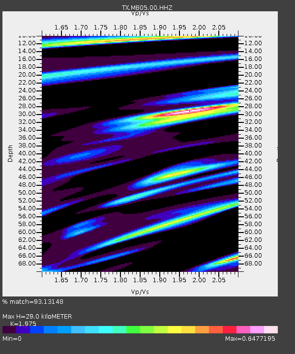
MB05 Klondike - Earthquake Result Viewer
| Earthquake location: |
Tonga Islands |
| Earthquake latitude/longitude: |
-18.7/-175.7 |
| Earthquake time(UTC): |
2019/11/04 (308) 22:46:10 GMT |
| Earthquake Depth: |
10 km |
| Earthquake Magnitude: |
5.5 mb |
| Earthquake Catalog/Contributor: |
NEIC PDE/us |
|
| Network: |
TX Texas Seismological Network |
| Station: |
MB05 Klondike |
| Lat/Lon: |
32.63 N/101.86 W |
| Elevation: |
882 m |
|
| Distance: |
87.0 deg |
| Az: |
54.251 deg |
| Baz: |
245.765 deg |
| Ray Param: |
0.043631632 |
| Estimated Moho Depth: |
29.0 km |
| Estimated Crust Vp/Vs: |
1.98 |
| Assumed Crust Vp: |
6.426 km/s |
| Estimated Crust Vs: |
3.254 km/s |
| Estimated Crust Poisson's Ratio: |
0.33 |
|
| Radial Match: |
93.13148 % |
| Radial Bump: |
385 |
| Transverse Match: |
70.624466 % |
| Transverse Bump: |
400 |
| SOD ConfigId: |
19951751 |
| Insert Time: |
2019-11-18 23:08:01.689 +0000 |
| GWidth: |
2.5 |
| Max Bumps: |
400 |
| Tol: |
0.001 |
|

Signal To Noise
| Channel | StoN | STA | LTA |
| TX:MB05:00:HHZ:20191104T22:58:24.790029Z | 1.0926796 | 7.7762445E-7 | 7.116674E-7 |
| TX:MB05:00:HH1:20191104T22:58:24.790029Z | 1.0297865 | 3.279664E-7 | 3.1848E-7 |
| TX:MB05:00:HH2:20191104T22:58:24.790029Z | 1.8407958 | 5.630207E-7 | 3.0585724E-7 |
| Arrivals |
| Ps | 4.5 SECOND |
| PpPs | 13 SECOND |
| PsPs/PpSs | 18 SECOND |


