You are here: Home > Network List > TX - Texas Seismological Network Stations List
> Station PB01 Permian Basin 1 > Earthquake Result Viewer
PB01 Permian Basin 1 - Earthquake Result Viewer
| Earthquake location: |
Tonga Islands |
| Earthquake latitude/longitude: |
-18.7/-175.7 |
| Earthquake time(UTC): |
2019/11/04 (308) 22:46:10 GMT |
| Earthquake Depth: |
10 km |
| Earthquake Magnitude: |
5.5 mb |
| Earthquake Catalog/Contributor: |
NEIC PDE/us |
|
| Network: |
TX Texas Seismological Network |
| Station: |
PB01 Permian Basin 1 |
| Lat/Lon: |
30.94 N/103.78 W |
| Elevation: |
1010 m |
|
| Distance: |
84.8 deg |
| Az: |
55.094 deg |
| Baz: |
244.818 deg |
| Ray Param: |
0.045204666 |
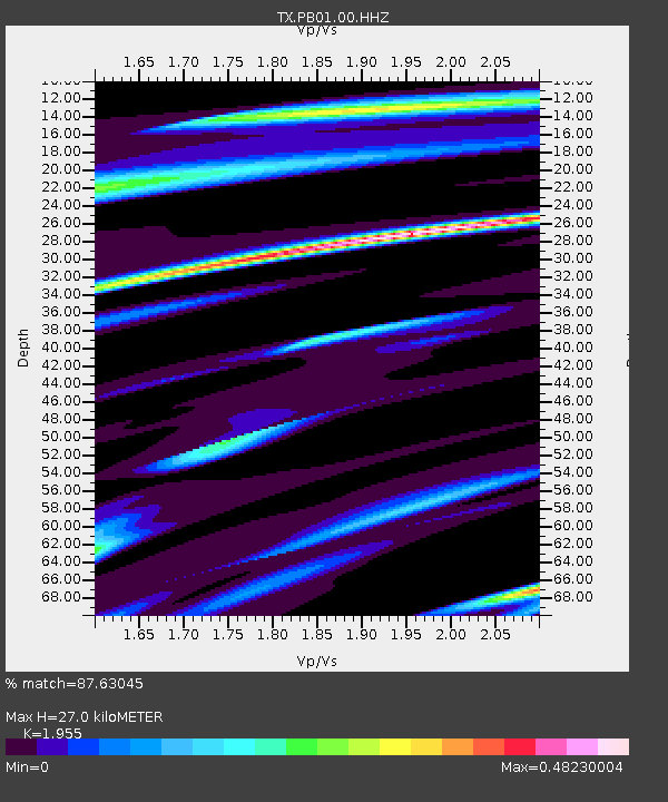
| Estimated Moho Depth: |
27.0 km |
| Estimated Crust Vp/Vs: |
1.96 |
| Assumed Crust Vp: |
6.121 km/s |
| Estimated Crust Vs: |
3.131 km/s |
| Estimated Crust Poisson's Ratio: |
0.32 |
|
| Radial Match: |
87.63045 % |
| Radial Bump: |
331 |
| Transverse Match: |
63.83748 % |
| Transverse Bump: |
400 |
| SOD ConfigId: |
19951751 |
| Insert Time: |
2019-11-18 23:08:03.094 +0000 |
| GWidth: |
2.5 |
| Max Bumps: |
400 |
| Tol: |
0.001 |
|

Signal To Noise
| Channel | StoN | STA | LTA |
| TX:PB01:00:HHZ:20191104T22:58:13.99999Z | 1.3188988 | 1.7234674E-6 | 1.3067473E-6 |
| TX:PB01:00:HH1:20191104T22:58:13.99999Z | 1.1179745 | 4.5106972E-7 | 4.0347052E-7 |
| TX:PB01:00:HH2:20191104T22:58:13.99999Z | 1.6480602 | 1.0532606E-6 | 6.390911E-7 |
| Arrivals |
| Ps | 4.3 SECOND |
| PpPs | 13 SECOND |
| PsPs/PpSs | 17 SECOND |


