You are here: Home > Network List > TX - Texas Seismological Network Stations List
> Station PB12 Southwest of Toyah > Earthquake Result Viewer
PB12 Southwest of Toyah - Earthquake Result Viewer
| Earthquake location: |
Tonga Islands |
| Earthquake latitude/longitude: |
-18.7/-175.7 |
| Earthquake time(UTC): |
2019/11/04 (308) 22:46:10 GMT |
| Earthquake Depth: |
10 km |
| Earthquake Magnitude: |
5.5 mb |
| Earthquake Catalog/Contributor: |
NEIC PDE/us |
|
| Network: |
TX Texas Seismological Network |
| Station: |
PB12 Southwest of Toyah |
| Lat/Lon: |
31.20 N/104.05 W |
| Elevation: |
962 m |
|
| Distance: |
84.7 deg |
| Az: |
54.766 deg |
| Baz: |
244.651 deg |
| Ray Param: |
0.04527561 |
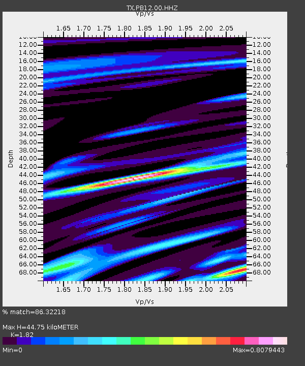
| Estimated Moho Depth: |
44.75 km |
| Estimated Crust Vp/Vs: |
1.82 |
| Assumed Crust Vp: |
6.361 km/s |
| Estimated Crust Vs: |
3.495 km/s |
| Estimated Crust Poisson's Ratio: |
0.28 |
|
| Radial Match: |
86.32218 % |
| Radial Bump: |
400 |
| Transverse Match: |
63.517693 % |
| Transverse Bump: |
400 |
| SOD ConfigId: |
19951751 |
| Insert Time: |
2019-11-18 23:08:06.012 +0000 |
| GWidth: |
2.5 |
| Max Bumps: |
400 |
| Tol: |
0.001 |
|

Signal To Noise
| Channel | StoN | STA | LTA |
| TX:PB12:00:HHZ:20191104T22:58:13.890005Z | 1.3059058 | 0.0012203414 | 9.344789E-4 |
| TX:PB12:00:HHN:20191104T22:58:13.890005Z | 0.63739717 | 1.8758052E-4 | 2.9429144E-4 |
| TX:PB12:00:HHE:20191104T22:58:13.890005Z | 1.7838097 | 8.216388E-4 | 4.6060898E-4 |
| Arrivals |
| Ps | 5.9 SECOND |
| PpPs | 19 SECOND |
| PsPs/PpSs | 25 SECOND |


