You are here: Home > Network List > TA - USArray Transportable Network (new EarthScope stations) Stations List
> Station Y26A Elida, NM, USA > Earthquake Result Viewer
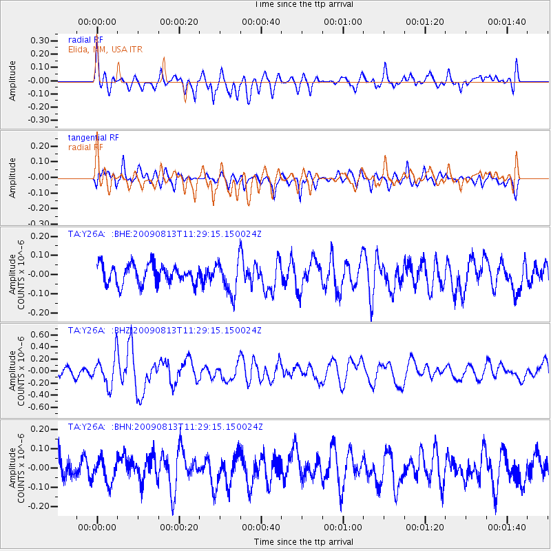
Y26A Elida, NM, USA - Earthquake Result Viewer
*The percent match for this event was below the threshold and hence no stack was calculated.
| Earthquake location: |
Tonga Islands |
| Earthquake latitude/longitude: |
-21.7/-174.6 |
| Earthquake time(UTC): |
2009/08/13 (225) 11:17:01 GMT |
| Earthquake Depth: |
10 km |
| Earthquake Magnitude: |
5.6 MW, 5.3 MB |
| Earthquake Catalog/Contributor: |
WHDF/NEIC |
|
| Network: |
TA USArray Transportable Network (new EarthScope stations) |
| Station: |
Y26A Elida, NM, USA |
| Lat/Lon: |
33.92 N/103.82 W |
| Elevation: |
1371 m |
|
| Distance: |
87.1 deg |
| Az: |
51.814 deg |
| Baz: |
241.56 deg |
| Ray Param: |
$rayparam |
*The percent match for this event was below the threshold and hence was not used in the summary stack. |
|
| Radial Match: |
73.04465 % |
| Radial Bump: |
400 |
| Transverse Match: |
52.70405 % |
| Transverse Bump: |
400 |
| SOD ConfigId: |
2622 |
| Insert Time: |
2010-03-07 05:35:45.025 +0000 |
| GWidth: |
2.5 |
| Max Bumps: |
400 |
| Tol: |
0.001 |
|
Signal To Noise
| Channel | StoN | STA | LTA |
| TA:Y26A: :BHZ:20090813T11:29:15.150024Z | 4.416926 | 2.604782E-7 | 5.8972734E-8 |
| TA:Y26A: :BHN:20090813T11:29:15.150024Z | 1.1562538 | 6.508432E-8 | 5.628896E-8 |
| TA:Y26A: :BHE:20090813T11:29:15.150024Z | 1.8328352 | 9.13916E-8 | 4.9863512E-8 |
| Arrivals |
| Ps | |
| PpPs | |
| PsPs/PpSs | |


