You are here: Home > Network List > IW - Intermountain West Stations List
> Station MOOW Moose Ponds, Wyoming, USA > Earthquake Result Viewer
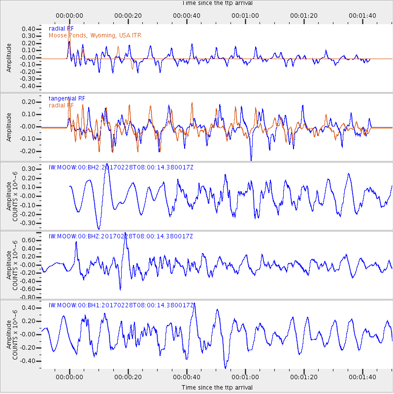
MOOW Moose Ponds, Wyoming, USA - Earthquake Result Viewer
*The percent match for this event was below the threshold and hence no stack was calculated.
| Earthquake location: |
Near East Coast Of Honshu, Japan |
| Earthquake latitude/longitude: |
37.6/141.3 |
| Earthquake time(UTC): |
2017/02/28 (059) 07:49:01 GMT |
| Earthquake Depth: |
38 km |
| Earthquake Magnitude: |
5.7 Mww |
| Earthquake Catalog/Contributor: |
NEIC PDE/us |
|
| Network: |
IW Intermountain West |
| Station: |
MOOW Moose Ponds, Wyoming, USA |
| Lat/Lon: |
43.75 N/110.74 W |
| Elevation: |
2128 m |
|
| Distance: |
76.1 deg |
| Az: |
45.26 deg |
| Baz: |
308.846 deg |
| Ray Param: |
$rayparam |
*The percent match for this event was below the threshold and hence was not used in the summary stack. |
|
| Radial Match: |
61.02284 % |
| Radial Bump: |
387 |
| Transverse Match: |
69.58293 % |
| Transverse Bump: |
371 |
| SOD ConfigId: |
1992691 |
| Insert Time: |
2017-03-14 07:53:53.389 +0000 |
| GWidth: |
2.5 |
| Max Bumps: |
400 |
| Tol: |
0.001 |
|
Signal To Noise
| Channel | StoN | STA | LTA |
| IW:MOOW:00:BHZ:20170228T08:00:14.380017Z | 2.1062453 | 2.275887E-7 | 1.0805422E-7 |
| IW:MOOW:00:BH1:20170228T08:00:14.380017Z | 1.5821605 | 1.6521858E-7 | 1.0442593E-7 |
| IW:MOOW:00:BH2:20170228T08:00:14.380017Z | 0.73782825 | 1.1758394E-7 | 1.5936492E-7 |
| Arrivals |
| Ps | |
| PpPs | |
| PsPs/PpSs | |


