You are here: Home > Network List > TA - USArray Transportable Network (new EarthScope stations) Stations List
> Station Y26A Elida, NM, USA > Earthquake Result Viewer
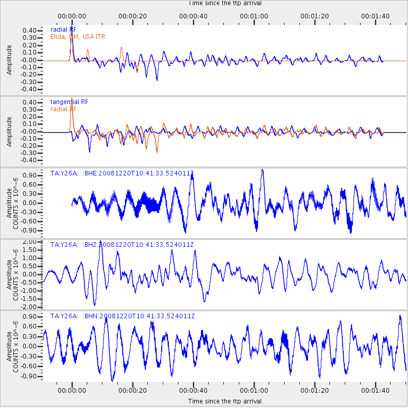
Y26A Elida, NM, USA - Earthquake Result Viewer
*The percent match for this event was below the threshold and hence no stack was calculated.
| Earthquake location: |
Off East Coast Of Honshu, Japan |
| Earthquake latitude/longitude: |
36.5/142.4 |
| Earthquake time(UTC): |
2008/12/20 (355) 10:29:23 GMT |
| Earthquake Depth: |
19 km |
| Earthquake Magnitude: |
6.0 MB, 6.3 MS, 6.3 MW, 6.3 MW |
| Earthquake Catalog/Contributor: |
WHDF/NEIC |
|
| Network: |
TA USArray Transportable Network (new EarthScope stations) |
| Station: |
Y26A Elida, NM, USA |
| Lat/Lon: |
33.92 N/103.82 W |
| Elevation: |
1371 m |
|
| Distance: |
86.6 deg |
| Az: |
49.681 deg |
| Baz: |
312.401 deg |
| Ray Param: |
$rayparam |
*The percent match for this event was below the threshold and hence was not used in the summary stack. |
|
| Radial Match: |
68.20138 % |
| Radial Bump: |
329 |
| Transverse Match: |
70.80952 % |
| Transverse Bump: |
400 |
| SOD ConfigId: |
2658 |
| Insert Time: |
2010-03-07 05:36:16.595 +0000 |
| GWidth: |
2.5 |
| Max Bumps: |
400 |
| Tol: |
0.001 |
|
Signal To Noise
| Channel | StoN | STA | LTA |
| TA:Y26A: :BHZ:20081220T10:41:33.524011Z | 2.7136884 | 5.757185E-7 | 2.1215351E-7 |
| TA:Y26A: :BHN:20081220T10:41:33.524011Z | 0.94871736 | 2.4398892E-7 | 2.5717767E-7 |
| TA:Y26A: :BHE:20081220T10:41:33.524011Z | 1.6571654 | 3.393607E-7 | 2.0478383E-7 |
| Arrivals |
| Ps | |
| PpPs | |
| PsPs/PpSs | |


