You are here: Home > Network List > TS - TERRAscope (Southern California Seismic Network) Stations List
> Station PAS Pasadena, California, USA > Earthquake Result Viewer
PAS Pasadena, California, USA - Earthquake Result Viewer
| Earthquake location: |
Costa Rica |
| Earthquake latitude/longitude: |
8.8/-84.0 |
| Earthquake time(UTC): |
2002/06/16 (167) 02:46:14 GMT |
| Earthquake Depth: |
35 km |
| Earthquake Magnitude: |
5.4 MB, 6.2 MS, 6.4 MW, 6.4 MW |
| Earthquake Catalog/Contributor: |
WHDF/NEIC |
|
| Network: |
TS TERRAscope (Southern California Seismic Network) |
| Station: |
PAS Pasadena, California, USA |
| Lat/Lon: |
34.15 N/118.17 W |
| Elevation: |
295 m |
|
| Distance: |
40.3 deg |
| Az: |
313.89 deg |
| Baz: |
120.805 deg |
| Ray Param: |
0.07442508 |
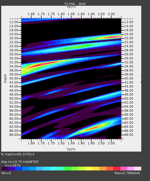
| Estimated Moho Depth: |
18.75 km |
| Estimated Crust Vp/Vs: |
2.10 |
| Assumed Crust Vp: |
6.1 km/s |
| Estimated Crust Vs: |
2.908 km/s |
| Estimated Crust Poisson's Ratio: |
0.35 |
|
| Radial Match: |
95.337814 % |
| Radial Bump: |
400 |
| Transverse Match: |
78.2307 % |
| Transverse Bump: |
400 |
| SOD ConfigId: |
20082 |
| Insert Time: |
2010-02-26 14:33:26.194 +0000 |
| GWidth: |
2.5 |
| Max Bumps: |
400 |
| Tol: |
0.001 |
|
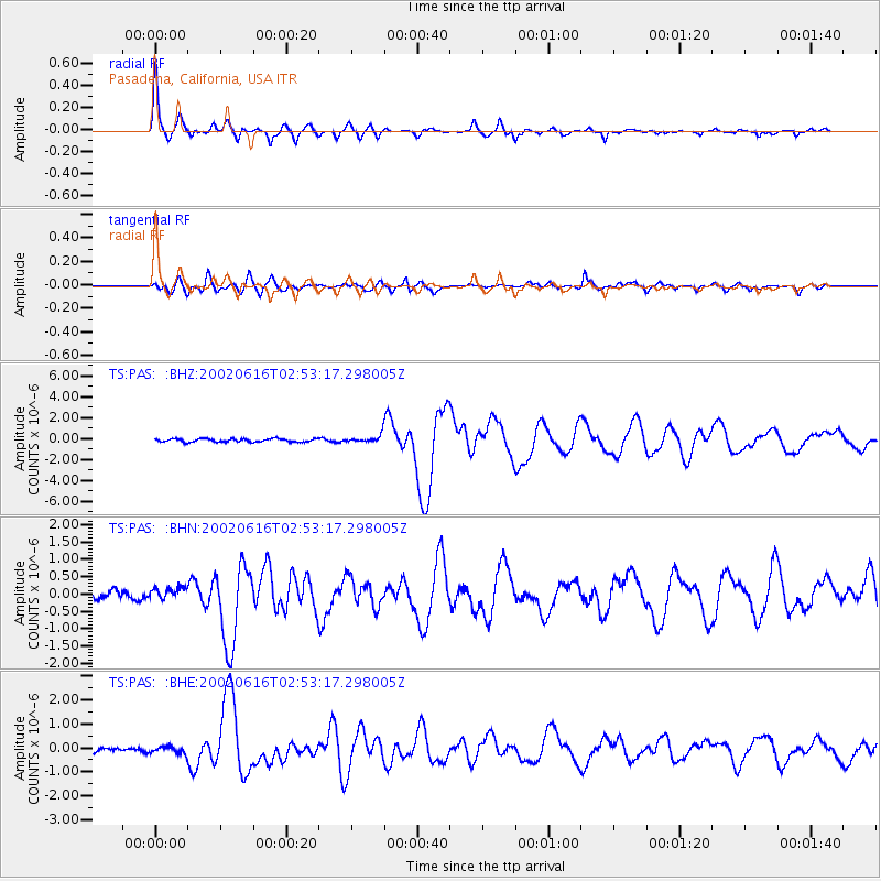
Signal To Noise
| Channel | StoN | STA | LTA |
| TS:PAS: :BHN:20020616T02:53:17.298005Z | 1.5716751 | 1.7532736E-7 | 1.11554456E-7 |
| TS:PAS: :BHE:20020616T02:53:17.298005Z | 1.6611774 | 1.4532398E-7 | 8.748252E-8 |
| TS:PAS: :BHZ:20020616T02:53:17.298005Z | 2.3410668 | 3.6776044E-7 | 1.5709095E-7 |
| Arrivals |
| Ps | 3.6 SECOND |
| PpPs | 9.0 SECOND |
| PsPs/PpSs | 13 SECOND |


