You are here: Home > Network List > TA - USArray Transportable Network (new EarthScope stations) Stations List
> Station Y26A Elida, NM, USA > Earthquake Result Viewer
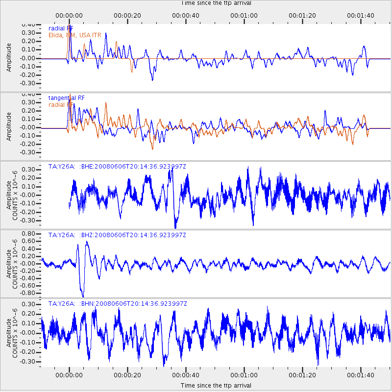
Y26A Elida, NM, USA - Earthquake Result Viewer
*The percent match for this event was below the threshold and hence no stack was calculated.
| Earthquake location: |
Northern Algeria |
| Earthquake latitude/longitude: |
35.9/-0.7 |
| Earthquake time(UTC): |
2008/06/06 (158) 20:02:56 GMT |
| Earthquake Depth: |
4.0 km |
| Earthquake Magnitude: |
5.5 MB, 5.3 MS, 5.5 MW, 5.5 MW |
| Earthquake Catalog/Contributor: |
WHDF/NEIC |
|
| Network: |
TA USArray Transportable Network (new EarthScope stations) |
| Station: |
Y26A Elida, NM, USA |
| Lat/Lon: |
33.92 N/103.82 W |
| Elevation: |
1371 m |
|
| Distance: |
80.2 deg |
| Az: |
304.748 deg |
| Baz: |
53.366 deg |
| Ray Param: |
$rayparam |
*The percent match for this event was below the threshold and hence was not used in the summary stack. |
|
| Radial Match: |
61.010113 % |
| Radial Bump: |
400 |
| Transverse Match: |
61.938423 % |
| Transverse Bump: |
400 |
| SOD ConfigId: |
2504 |
| Insert Time: |
2010-03-07 05:36:27.202 +0000 |
| GWidth: |
2.5 |
| Max Bumps: |
400 |
| Tol: |
0.001 |
|
Signal To Noise
| Channel | StoN | STA | LTA |
| TA:Y26A: :BHZ:20080606T20:14:36.923997Z | 3.8694153 | 3.831293E-7 | 9.901478E-8 |
| TA:Y26A: :BHN:20080606T20:14:36.923997Z | 0.93193626 | 9.412364E-8 | 1.00997944E-7 |
| TA:Y26A: :BHE:20080606T20:14:36.923997Z | 1.3945469 | 1.2710001E-7 | 9.114072E-8 |
| Arrivals |
| Ps | |
| PpPs | |
| PsPs/PpSs | |


