You are here: Home > Network List > US - United States National Seismic Network Stations List
> Station EGMT Eagleton, Montana, USA > Earthquake Result Viewer
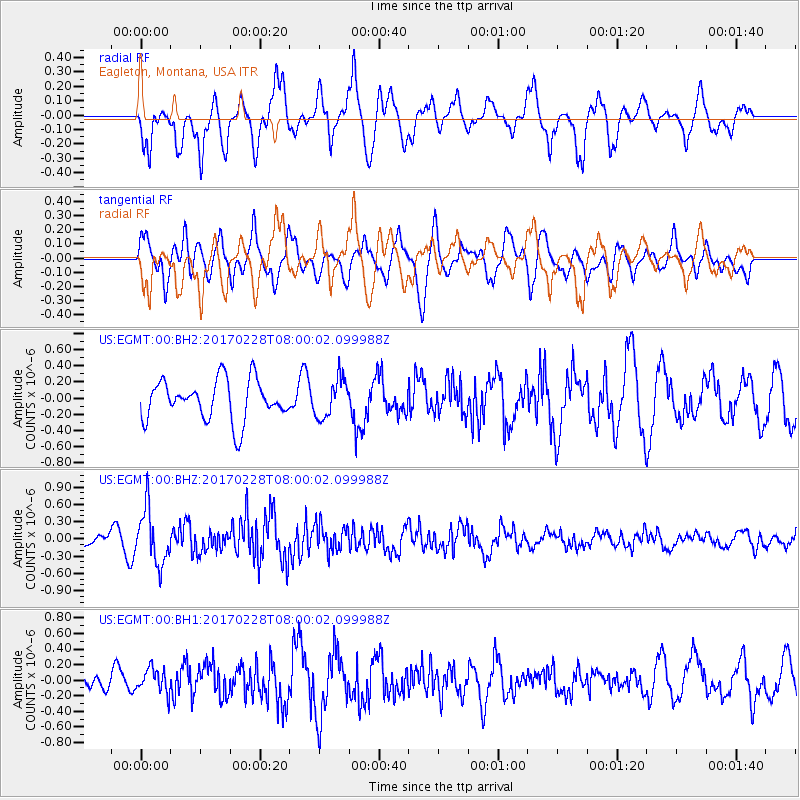
EGMT Eagleton, Montana, USA - Earthquake Result Viewer
*The percent match for this event was below the threshold and hence no stack was calculated.
| Earthquake location: |
Near East Coast Of Honshu, Japan |
| Earthquake latitude/longitude: |
37.6/141.3 |
| Earthquake time(UTC): |
2017/02/28 (059) 07:49:01 GMT |
| Earthquake Depth: |
38 km |
| Earthquake Magnitude: |
5.7 Mww |
| Earthquake Catalog/Contributor: |
NEIC PDE/us |
|
| Network: |
US United States National Seismic Network |
| Station: |
EGMT Eagleton, Montana, USA |
| Lat/Lon: |
48.02 N/109.75 W |
| Elevation: |
1055 m |
|
| Distance: |
73.9 deg |
| Az: |
41.357 deg |
| Baz: |
308.544 deg |
| Ray Param: |
$rayparam |
*The percent match for this event was below the threshold and hence was not used in the summary stack. |
|
| Radial Match: |
68.92577 % |
| Radial Bump: |
400 |
| Transverse Match: |
61.63019 % |
| Transverse Bump: |
400 |
| SOD ConfigId: |
1992691 |
| Insert Time: |
2017-03-14 07:55:27.786 +0000 |
| GWidth: |
2.5 |
| Max Bumps: |
400 |
| Tol: |
0.001 |
|
Signal To Noise
| Channel | StoN | STA | LTA |
| US:EGMT:00:BHZ:20170228T08:00:02.099988Z | 3.3165953 | 4.7354075E-7 | 1.4277919E-7 |
| US:EGMT:00:BH1:20170228T08:00:02.099988Z | 0.69701946 | 1.569715E-7 | 2.2520389E-7 |
| US:EGMT:00:BH2:20170228T08:00:02.099988Z | 0.9668385 | 2.4065034E-7 | 2.4890437E-7 |
| Arrivals |
| Ps | |
| PpPs | |
| PsPs/PpSs | |


