You are here: Home > Network List > TA - USArray Transportable Network (new EarthScope stations) Stations List
> Station Y26A Elida, NM, USA > Earthquake Result Viewer
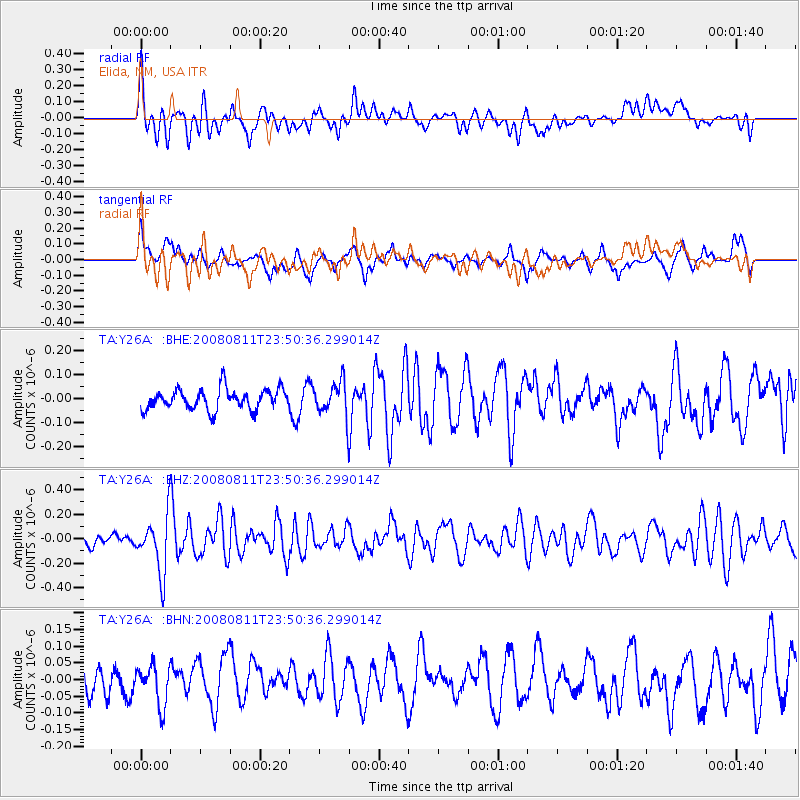
Y26A Elida, NM, USA - Earthquake Result Viewer
*The percent match for this event was below the threshold and hence no stack was calculated.
| Earthquake location: |
Central Mid-Atlantic Ridge |
| Earthquake latitude/longitude: |
-1.0/-21.8 |
| Earthquake time(UTC): |
2008/08/11 (224) 23:38:38 GMT |
| Earthquake Depth: |
13 km |
| Earthquake Magnitude: |
6.0 MW, 5.2 MS, 5.4 MB, 6.0 MW |
| Earthquake Catalog/Contributor: |
WHDF/NEIC |
|
| Network: |
TA USArray Transportable Network (new EarthScope stations) |
| Station: |
Y26A Elida, NM, USA |
| Lat/Lon: |
33.92 N/103.82 W |
| Elevation: |
1371 m |
|
| Distance: |
83.9 deg |
| Az: |
304.1 deg |
| Baz: |
95.319 deg |
| Ray Param: |
$rayparam |
*The percent match for this event was below the threshold and hence was not used in the summary stack. |
|
| Radial Match: |
53.769215 % |
| Radial Bump: |
400 |
| Transverse Match: |
65.8199 % |
| Transverse Bump: |
400 |
| SOD ConfigId: |
2504 |
| Insert Time: |
2010-03-07 05:36:28.822 +0000 |
| GWidth: |
2.5 |
| Max Bumps: |
400 |
| Tol: |
0.001 |
|
Signal To Noise
| Channel | StoN | STA | LTA |
| TA:Y26A: :BHZ:20080811T23:50:36.299014Z | 2.7533903 | 2.3248975E-7 | 8.443763E-8 |
| TA:Y26A: :BHN:20080811T23:50:36.299014Z | 1.0406045 | 6.185205E-8 | 5.9438577E-8 |
| TA:Y26A: :BHE:20080811T23:50:36.299014Z | 1.6991524 | 7.2397846E-8 | 4.2608214E-8 |
| Arrivals |
| Ps | |
| PpPs | |
| PsPs/PpSs | |


