You are here: Home > Network List > US - United States National Seismic Network Stations List
> Station MSO Missoula, Montana, USA > Earthquake Result Viewer
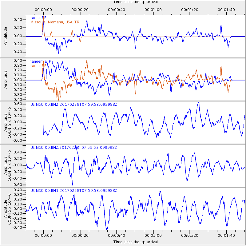
MSO Missoula, Montana, USA - Earthquake Result Viewer
*The percent match for this event was below the threshold and hence no stack was calculated.
| Earthquake location: |
Near East Coast Of Honshu, Japan |
| Earthquake latitude/longitude: |
37.6/141.3 |
| Earthquake time(UTC): |
2017/02/28 (059) 07:49:01 GMT |
| Earthquake Depth: |
38 km |
| Earthquake Magnitude: |
5.7 Mww |
| Earthquake Catalog/Contributor: |
NEIC PDE/us |
|
| Network: |
US United States National Seismic Network |
| Station: |
MSO Missoula, Montana, USA |
| Lat/Lon: |
46.83 N/113.94 W |
| Elevation: |
1264 m |
|
| Distance: |
72.4 deg |
| Az: |
44.153 deg |
| Baz: |
306.28 deg |
| Ray Param: |
$rayparam |
*The percent match for this event was below the threshold and hence was not used in the summary stack. |
|
| Radial Match: |
47.707523 % |
| Radial Bump: |
400 |
| Transverse Match: |
39.523895 % |
| Transverse Bump: |
400 |
| SOD ConfigId: |
1992691 |
| Insert Time: |
2017-03-14 07:55:48.239 +0000 |
| GWidth: |
2.5 |
| Max Bumps: |
400 |
| Tol: |
0.001 |
|
Signal To Noise
| Channel | StoN | STA | LTA |
| US:MSO:00:BHZ:20170228T07:59:53.099988Z | 2.5057395 | 1.9714192E-7 | 7.867614E-8 |
| US:MSO:00:BH1:20170228T07:59:53.099988Z | 1.6462668 | 1.0225364E-7 | 6.2112434E-8 |
| US:MSO:00:BH2:20170228T07:59:53.099988Z | 1.1871322 | 2.5450015E-7 | 2.1438231E-7 |
| Arrivals |
| Ps | |
| PpPs | |
| PsPs/PpSs | |


