You are here: Home > Network List > US - United States National Seismic Network Stations List
> Station HAWA Hanford, Washington, USA > Earthquake Result Viewer
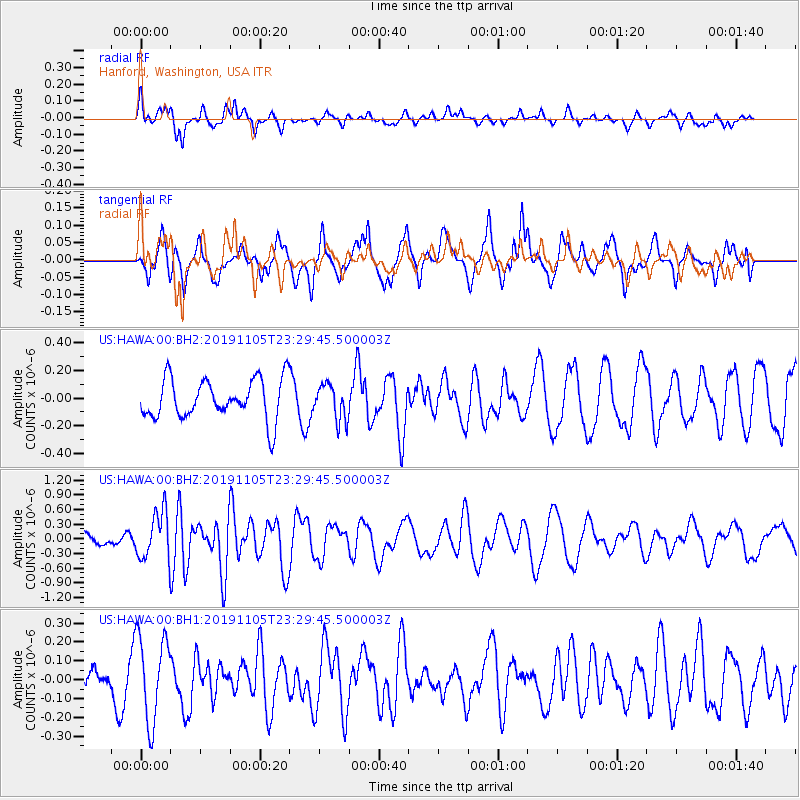
HAWA Hanford, Washington, USA - Earthquake Result Viewer
*The percent match for this event was below the threshold and hence no stack was calculated.
| Earthquake location: |
Vanuatu Islands |
| Earthquake latitude/longitude: |
-13.8/167.7 |
| Earthquake time(UTC): |
2019/11/05 (309) 23:17:25 GMT |
| Earthquake Depth: |
10 km |
| Earthquake Magnitude: |
5.9 Mww |
| Earthquake Catalog/Contributor: |
NEIC PDE/us |
|
| Network: |
US United States National Seismic Network |
| Station: |
HAWA Hanford, Washington, USA |
| Lat/Lon: |
46.39 N/119.53 W |
| Elevation: |
364 m |
|
| Distance: |
88.4 deg |
| Az: |
41.395 deg |
| Baz: |
248.141 deg |
| Ray Param: |
$rayparam |
*The percent match for this event was below the threshold and hence was not used in the summary stack. |
|
| Radial Match: |
66.05453 % |
| Radial Bump: |
373 |
| Transverse Match: |
70.8344 % |
| Transverse Bump: |
400 |
| SOD ConfigId: |
19951751 |
| Insert Time: |
2019-11-19 23:29:46.313 +0000 |
| GWidth: |
2.5 |
| Max Bumps: |
400 |
| Tol: |
0.001 |
|
Signal To Noise
| Channel | StoN | STA | LTA |
| US:HAWA:00:BHZ:20191105T23:29:45.500003Z | 3.2644768 | 4.9462415E-7 | 1.5151713E-7 |
| US:HAWA:00:BH1:20191105T23:29:45.500003Z | 1.8937213 | 2.2560508E-7 | 1.191332E-7 |
| US:HAWA:00:BH2:20191105T23:29:45.500003Z | 0.8866391 | 1.2825446E-7 | 1.4465238E-7 |
| Arrivals |
| Ps | |
| PpPs | |
| PsPs/PpSs | |


