You are here: Home > Network List > TA - USArray Transportable Network (new EarthScope stations) Stations List
> Station E20K Nigu River, AK, USA > Earthquake Result Viewer
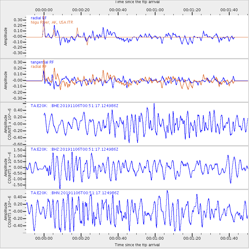
E20K Nigu River, AK, USA - Earthquake Result Viewer
*The percent match for this event was below the threshold and hence no stack was calculated.
| Earthquake location: |
Vanuatu Islands |
| Earthquake latitude/longitude: |
-13.7/167.8 |
| Earthquake time(UTC): |
2019/11/06 (310) 00:39:09 GMT |
| Earthquake Depth: |
10 km |
| Earthquake Magnitude: |
5.8 Mww |
| Earthquake Catalog/Contributor: |
NEIC PDE/us |
|
| Network: |
TA USArray Transportable Network (new EarthScope stations) |
| Station: |
E20K Nigu River, AK, USA |
| Lat/Lon: |
68.26 N/156.19 W |
| Elevation: |
866 m |
|
| Distance: |
85.8 deg |
| Az: |
12.686 deg |
| Baz: |
214.945 deg |
| Ray Param: |
$rayparam |
*The percent match for this event was below the threshold and hence was not used in the summary stack. |
|
| Radial Match: |
72.680275 % |
| Radial Bump: |
400 |
| Transverse Match: |
62.097965 % |
| Transverse Bump: |
400 |
| SOD ConfigId: |
19951751 |
| Insert Time: |
2019-11-20 00:47:58.079 +0000 |
| GWidth: |
2.5 |
| Max Bumps: |
400 |
| Tol: |
0.001 |
|
Signal To Noise
| Channel | StoN | STA | LTA |
| TA:E20K: :BHZ:20191106T00:51:17.124986Z | 1.9775659 | 4.0388903E-7 | 2.0423543E-7 |
| TA:E20K: :BHN:20191106T00:51:17.124986Z | 1.0774175 | 1.9003029E-7 | 1.7637572E-7 |
| TA:E20K: :BHE:20191106T00:51:17.124986Z | 0.78186274 | 1.3408254E-7 | 1.7149115E-7 |
| Arrivals |
| Ps | |
| PpPs | |
| PsPs/PpSs | |


