You are here: Home > Network List > TS - TERRAscope (Southern California Seismic Network) Stations List
> Station PAS Pasadena, California, USA > Earthquake Result Viewer
PAS Pasadena, California, USA - Earthquake Result Viewer
| Earthquake location: |
Vanuatu Islands |
| Earthquake latitude/longitude: |
-17.6/167.9 |
| Earthquake time(UTC): |
2002/01/02 (002) 17:22:48 GMT |
| Earthquake Depth: |
21 km |
| Earthquake Magnitude: |
6.3 MB, 7.5 MS, 7.3 MW, 7.1 MW |
| Earthquake Catalog/Contributor: |
WHDF/NEIC |
|
| Network: |
TS TERRAscope (Southern California Seismic Network) |
| Station: |
PAS Pasadena, California, USA |
| Lat/Lon: |
34.15 N/118.17 W |
| Elevation: |
295 m |
|
| Distance: |
87.1 deg |
| Az: |
52.95 deg |
| Baz: |
246.616 deg |
| Ray Param: |
0.04354372 |
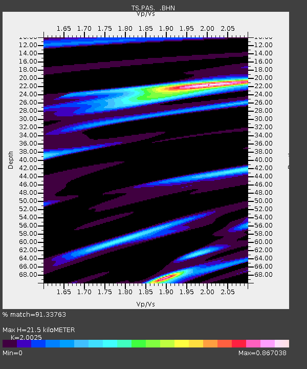
| Estimated Moho Depth: |
21.5 km |
| Estimated Crust Vp/Vs: |
2.00 |
| Assumed Crust Vp: |
6.1 km/s |
| Estimated Crust Vs: |
3.046 km/s |
| Estimated Crust Poisson's Ratio: |
0.33 |
|
| Radial Match: |
91.33763 % |
| Radial Bump: |
400 |
| Transverse Match: |
89.747765 % |
| Transverse Bump: |
400 |
| SOD ConfigId: |
20082 |
| Insert Time: |
2010-02-26 14:33:34.756 +0000 |
| GWidth: |
2.5 |
| Max Bumps: |
400 |
| Tol: |
0.001 |
|
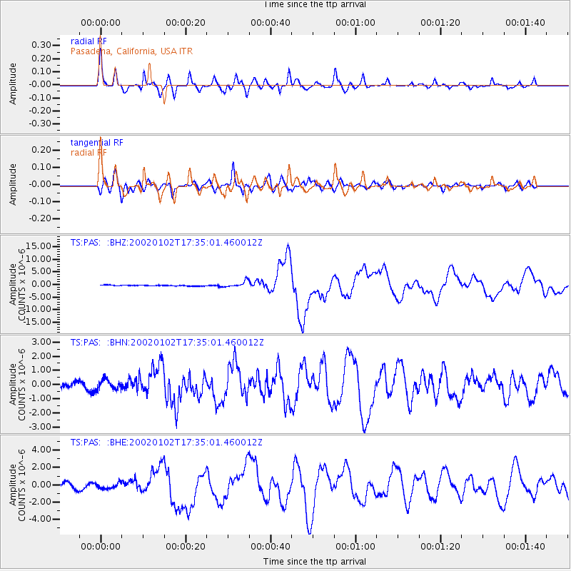
Signal To Noise
| Channel | StoN | STA | LTA |
| TS:PAS: :BHN:20020102T17:35:01.460012Z | 1.4348652 | 3.4342926E-7 | 2.39346E-7 |
| TS:PAS: :BHE:20020102T17:35:01.460012Z | 0.88903606 | 3.1409982E-7 | 3.5330382E-7 |
| TS:PAS: :BHZ:20020102T17:35:01.460012Z | 7.1994843 | 1.249677E-6 | 1.7357868E-7 |
| Arrivals |
| Ps | 3.6 SECOND |
| PpPs | 10 SECOND |
| PsPs/PpSs | 14 SECOND |


