You are here: Home > Network List > TA - USArray Transportable Network (new EarthScope stations) Stations List
> Station L24A Wheatland, WY, USA > Earthquake Result Viewer
L24A Wheatland, WY, USA - Earthquake Result Viewer
| Earthquake location: |
Kuril Islands |
| Earthquake latitude/longitude: |
46.0/151.4 |
| Earthquake time(UTC): |
2009/04/18 (108) 19:17:58 GMT |
| Earthquake Depth: |
35 km |
| Earthquake Magnitude: |
6.3 MB, 6.3 MS, 6.6 MW, 6.4 MW |
| Earthquake Catalog/Contributor: |
WHDF/NEIC |
|
| Network: |
TA USArray Transportable Network (new EarthScope stations) |
| Station: |
L24A Wheatland, WY, USA |
| Lat/Lon: |
42.04 N/104.93 W |
| Elevation: |
1479 m |
|
| Distance: |
69.1 deg |
| Az: |
50.773 deg |
| Baz: |
313.553 deg |
| Ray Param: |
0.055789907 |
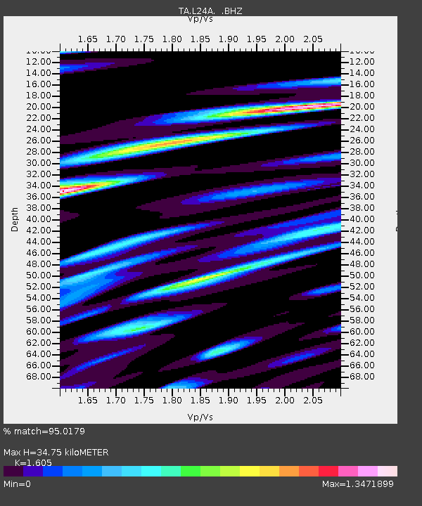
| Estimated Moho Depth: |
34.75 km |
| Estimated Crust Vp/Vs: |
1.61 |
| Assumed Crust Vp: |
6.159 km/s |
| Estimated Crust Vs: |
3.837 km/s |
| Estimated Crust Poisson's Ratio: |
0.18 |
|
| Radial Match: |
95.0179 % |
| Radial Bump: |
400 |
| Transverse Match: |
89.02566 % |
| Transverse Bump: |
400 |
| SOD ConfigId: |
2760 |
| Insert Time: |
2010-03-07 05:38:31.241 +0000 |
| GWidth: |
2.5 |
| Max Bumps: |
400 |
| Tol: |
0.001 |
|

Signal To Noise
| Channel | StoN | STA | LTA |
| TA:L24A: :BHZ:20090418T19:28:30.799019Z | 17.536085 | 2.3808818E-6 | 1.3577042E-7 |
| TA:L24A: :BHN:20090418T19:28:30.799019Z | 5.1328177 | 8.809118E-7 | 1.7162344E-7 |
| TA:L24A: :BHE:20090418T19:28:30.799019Z | 4.243123 | 9.49447E-7 | 2.2376135E-7 |
| Arrivals |
| Ps | 3.5 SECOND |
| PpPs | 14 SECOND |
| PsPs/PpSs | 18 SECOND |


