You are here: Home > Network List > TS - TERRAscope (Southern California Seismic Network) Stations List
> Station PAS Pasadena, California, USA > Earthquake Result Viewer
PAS Pasadena, California, USA - Earthquake Result Viewer
| Earthquake location: |
Northwest Of Kuril Islands |
| Earthquake latitude/longitude: |
47.8/146.2 |
| Earthquake time(UTC): |
2002/11/17 (321) 04:53:53 GMT |
| Earthquake Depth: |
459 km |
| Earthquake Magnitude: |
7.3 MW, 7.3 MW |
| Earthquake Catalog/Contributor: |
WHDF/NEIC |
|
| Network: |
TS TERRAscope (Southern California Seismic Network) |
| Station: |
PAS Pasadena, California, USA |
| Lat/Lon: |
34.15 N/118.17 W |
| Elevation: |
295 m |
|
| Distance: |
69.0 deg |
| Az: |
62.125 deg |
| Baz: |
314.087 deg |
| Ray Param: |
0.054419804 |
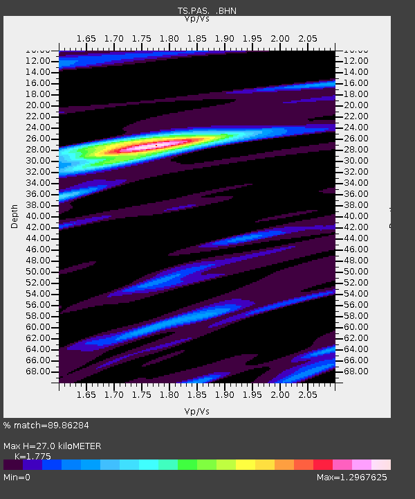
| Estimated Moho Depth: |
27.0 km |
| Estimated Crust Vp/Vs: |
1.77 |
| Assumed Crust Vp: |
6.1 km/s |
| Estimated Crust Vs: |
3.437 km/s |
| Estimated Crust Poisson's Ratio: |
0.27 |
|
| Radial Match: |
89.86284 % |
| Radial Bump: |
400 |
| Transverse Match: |
81.03634 % |
| Transverse Bump: |
400 |
| SOD ConfigId: |
4714 |
| Insert Time: |
2010-02-26 14:33:36.358 +0000 |
| GWidth: |
2.5 |
| Max Bumps: |
400 |
| Tol: |
0.001 |
|
Signal To Noise
| Channel | StoN | STA | LTA |
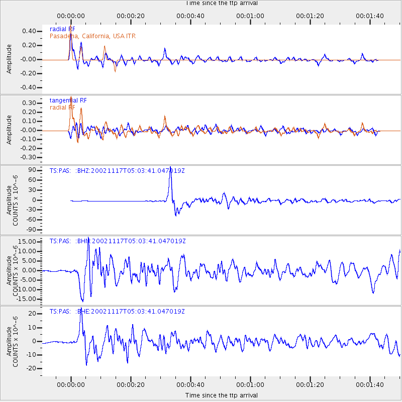
| TS:PAS: :BHN:20021117T05:03:41.047019Z | 20.183815 | 7.0454635E-6 | 3.49065E-7 |
| TS:PAS: :BHE:20021117T05:03:41.047019Z | 17.760883 | 8.82634E-6 | 4.969538E-7 |
| TS:PAS: :BHZ:20021117T05:03:41.047019Z | 114.19973 | 3.469958E-5 | 3.0384993E-7 |
| Arrivals |
| Ps | 3.5 SECOND |
| PpPs | 12 SECOND |
| PsPs/PpSs | 15 SECOND |


