You are here: Home > Network List > TA - USArray Transportable Network (new EarthScope stations) Stations List
> Station L24A Wheatland, WY, USA > Earthquake Result Viewer
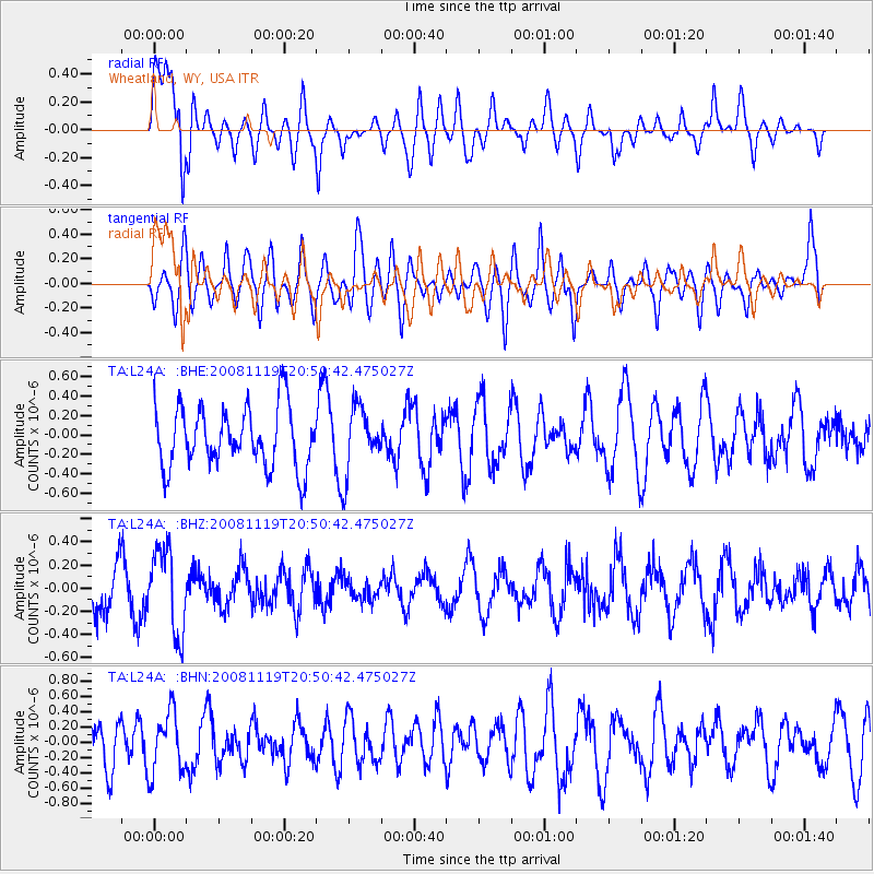
L24A Wheatland, WY, USA - Earthquake Result Viewer
*The percent match for this event was below the threshold and hence no stack was calculated.
| Earthquake location: |
South Of Fiji Islands |
| Earthquake latitude/longitude: |
-22.2/-179.7 |
| Earthquake time(UTC): |
2008/11/19 (324) 20:38:58 GMT |
| Earthquake Depth: |
596 km |
| Earthquake Magnitude: |
5.8 MW, 5.2 MB, 5.8 MW |
| Earthquake Catalog/Contributor: |
WHDF/NEIC |
|
| Network: |
TA USArray Transportable Network (new EarthScope stations) |
| Station: |
L24A Wheatland, WY, USA |
| Lat/Lon: |
42.04 N/104.93 W |
| Elevation: |
1479 m |
|
| Distance: |
94.0 deg |
| Az: |
46.094 deg |
| Baz: |
243.716 deg |
| Ray Param: |
$rayparam |
*The percent match for this event was below the threshold and hence was not used in the summary stack. |
|
| Radial Match: |
70.33854 % |
| Radial Bump: |
400 |
| Transverse Match: |
53.503395 % |
| Transverse Bump: |
400 |
| SOD ConfigId: |
2658 |
| Insert Time: |
2010-03-07 05:39:07.036 +0000 |
| GWidth: |
2.5 |
| Max Bumps: |
400 |
| Tol: |
0.001 |
|
Signal To Noise
| Channel | StoN | STA | LTA |
| TA:L24A: :BHZ:20081119T20:50:42.475027Z | 2.0399785 | 3.6269032E-7 | 1.7779125E-7 |
| TA:L24A: :BHN:20081119T20:50:42.475027Z | 1.2646549 | 3.9842328E-7 | 3.1504507E-7 |
| TA:L24A: :BHE:20081119T20:50:42.475027Z | 1.063737 | 3.3302695E-7 | 3.1307263E-7 |
| Arrivals |
| Ps | |
| PpPs | |
| PsPs/PpSs | |


