You are here: Home > Network List > TA - USArray Transportable Network (new EarthScope stations) Stations List
> Station L24A Wheatland, WY, USA > Earthquake Result Viewer
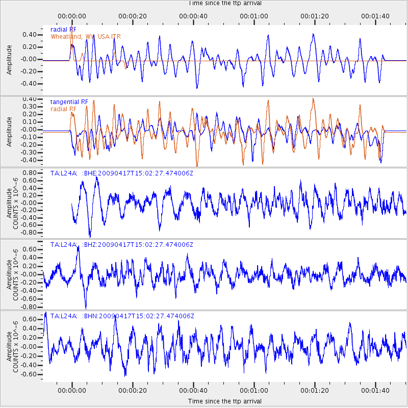
L24A Wheatland, WY, USA - Earthquake Result Viewer
*The percent match for this event was below the threshold and hence no stack was calculated.
| Earthquake location: |
Kuril Islands |
| Earthquake latitude/longitude: |
46.2/151.7 |
| Earthquake time(UTC): |
2009/04/17 (107) 14:51:58 GMT |
| Earthquake Depth: |
49 km |
| Earthquake Magnitude: |
5.5 MB, 5.0 MS, 5.7 MW, 5.6 MW |
| Earthquake Catalog/Contributor: |
WHDF/NEIC |
|
| Network: |
TA USArray Transportable Network (new EarthScope stations) |
| Station: |
L24A Wheatland, WY, USA |
| Lat/Lon: |
42.04 N/104.93 W |
| Elevation: |
1479 m |
|
| Distance: |
68.9 deg |
| Az: |
50.97 deg |
| Baz: |
313.55 deg |
| Ray Param: |
$rayparam |
*The percent match for this event was below the threshold and hence was not used in the summary stack. |
|
| Radial Match: |
56.739925 % |
| Radial Bump: |
400 |
| Transverse Match: |
53.734478 % |
| Transverse Bump: |
400 |
| SOD ConfigId: |
2658 |
| Insert Time: |
2010-03-07 05:39:28.306 +0000 |
| GWidth: |
2.5 |
| Max Bumps: |
400 |
| Tol: |
0.001 |
|
Signal To Noise
| Channel | StoN | STA | LTA |
| TA:L24A: :BHZ:20090417T15:02:27.474006Z | 2.5465944 | 3.6435907E-7 | 1.4307699E-7 |
| TA:L24A: :BHN:20090417T15:02:27.474006Z | 0.6456423 | 1.9773536E-7 | 3.0626146E-7 |
| TA:L24A: :BHE:20090417T15:02:27.474006Z | 0.96757036 | 3.1232815E-7 | 3.2279632E-7 |
| Arrivals |
| Ps | |
| PpPs | |
| PsPs/PpSs | |


