You are here: Home > Network List > PF - Volcanologic Network of Piton de Fournaise-OVPF Stations List
> Station HIM cratere Himiltrude > Earthquake Result Viewer
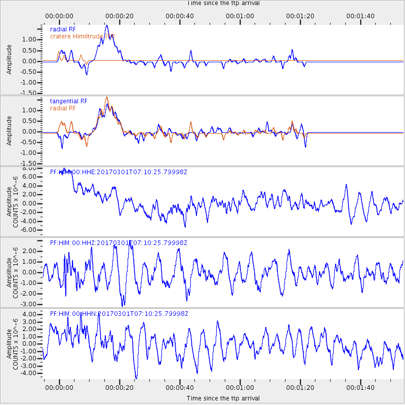
HIM cratere Himiltrude - Earthquake Result Viewer
*The percent match for this event was below the threshold and hence no stack was calculated.
| Earthquake location: |
Banda Sea |
| Earthquake latitude/longitude: |
-6.3/130.0 |
| Earthquake time(UTC): |
2017/03/01 (060) 06:59:40 GMT |
| Earthquake Depth: |
131 km |
| Earthquake Magnitude: |
5.5 mb |
| Earthquake Catalog/Contributor: |
NEIC PDE/us |
|
| Network: |
PF Volcanologic Network of Piton de Fournaise-OVPF |
| Station: |
HIM cratere Himiltrude |
| Lat/Lon: |
21.21 S/55.72 E |
| Elevation: |
1958 m |
|
| Distance: |
73.1 deg |
| Az: |
249.833 deg |
| Baz: |
90.324 deg |
| Ray Param: |
$rayparam |
*The percent match for this event was below the threshold and hence was not used in the summary stack. |
|
| Radial Match: |
25.009136 % |
| Radial Bump: |
400 |
| Transverse Match: |
32.895264 % |
| Transverse Bump: |
400 |
| SOD ConfigId: |
1992691 |
| Insert Time: |
2017-03-15 07:01:33.258 +0000 |
| GWidth: |
2.5 |
| Max Bumps: |
400 |
| Tol: |
0.001 |
|
Signal To Noise
| Channel | StoN | STA | LTA |
| PF:HIM:00:HHZ:20170301T07:10:25.79998Z | 1.6825355 | 1.0080172E-6 | 5.9910604E-7 |
| PF:HIM:00:HHN:20170301T07:10:25.79998Z | 1.7043169 | 4.0579375E-6 | 2.3809762E-6 |
| PF:HIM:00:HHE:20170301T07:10:25.79998Z | 2.0298114 | 5.1371235E-6 | 2.530838E-6 |
| Arrivals |
| Ps | |
| PpPs | |
| PsPs/PpSs | |


