You are here: Home > Network List > TA - USArray Transportable Network (new EarthScope stations) Stations List
> Station L24A Wheatland, WY, USA > Earthquake Result Viewer
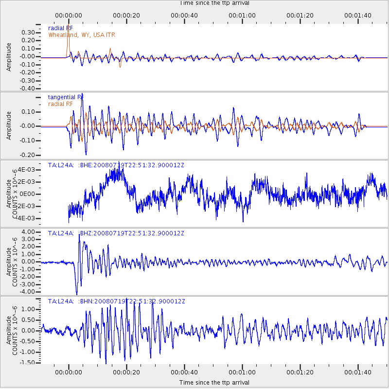
L24A Wheatland, WY, USA - Earthquake Result Viewer
*The percent match for this event was below the threshold and hence no stack was calculated.
| Earthquake location: |
Fiji Islands Region |
| Earthquake latitude/longitude: |
-17.3/-177.3 |
| Earthquake time(UTC): |
2008/07/19 (201) 22:39:52 GMT |
| Earthquake Depth: |
391 km |
| Earthquake Magnitude: |
5.9 MB, 6.4 MW, 6.4 MW |
| Earthquake Catalog/Contributor: |
WHDF/NEIC |
|
| Network: |
TA USArray Transportable Network (new EarthScope stations) |
| Station: |
L24A Wheatland, WY, USA |
| Lat/Lon: |
42.04 N/104.93 W |
| Elevation: |
1479 m |
|
| Distance: |
89.0 deg |
| Az: |
45.238 deg |
| Baz: |
245.57 deg |
| Ray Param: |
$rayparam |
*The percent match for this event was below the threshold and hence was not used in the summary stack. |
|
| Radial Match: |
73.28188 % |
| Radial Bump: |
400 |
| Transverse Match: |
73.216934 % |
| Transverse Bump: |
400 |
| SOD ConfigId: |
2504 |
| Insert Time: |
2010-03-07 05:40:09.929 +0000 |
| GWidth: |
2.5 |
| Max Bumps: |
400 |
| Tol: |
0.001 |
|
Signal To Noise
| Channel | StoN | STA | LTA |
| TA:L24A: :BHZ:20080719T22:51:32.900012Z | 24.904625 | 1.8726914E-6 | 7.519453E-8 |
| TA:L24A: :BHN:20080719T22:51:32.900012Z | 1.4136207 | 1.9252896E-7 | 1.3619562E-7 |
| TA:L24A: :BHE:20080719T22:51:32.900012Z | 0.47982246 | 1.0751151E-9 | 2.240652E-9 |
| Arrivals |
| Ps | |
| PpPs | |
| PsPs/PpSs | |


