You are here: Home > Network List > GS - US Geological Survey Networks Stations List
> Station KAN08 Pence Farm, Harper, KS, USA > Earthquake Result Viewer
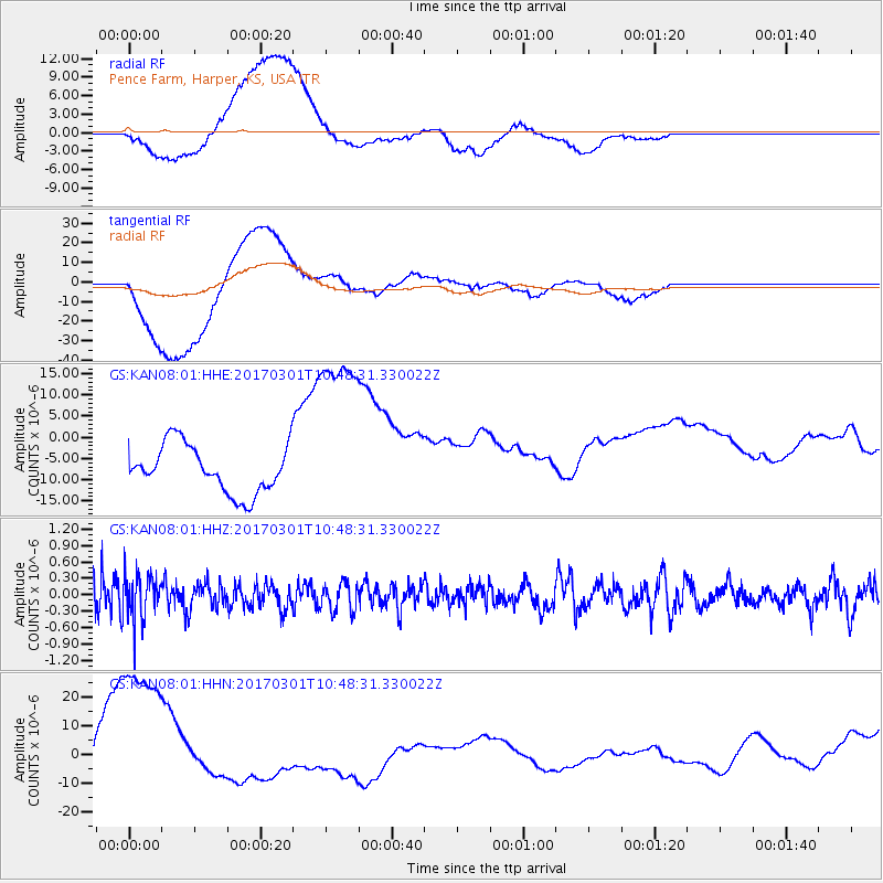
KAN08 Pence Farm, Harper, KS, USA - Earthquake Result Viewer
*The percent match for this event was below the threshold and hence no stack was calculated.
| Earthquake location: |
Andreanof Islands, Aleutian Is. |
| Earthquake latitude/longitude: |
52.2/-173.4 |
| Earthquake time(UTC): |
2017/03/01 (060) 10:39:49 GMT |
| Earthquake Depth: |
58 km |
| Earthquake Magnitude: |
5.5 mb |
| Earthquake Catalog/Contributor: |
NEIC PDE/us |
|
| Network: |
GS US Geological Survey Networks |
| Station: |
KAN08 Pence Farm, Harper, KS, USA |
| Lat/Lon: |
37.23 N/97.97 W |
| Elevation: |
375 m |
|
| Distance: |
53.2 deg |
| Az: |
74.625 deg |
| Baz: |
311.932 deg |
| Ray Param: |
$rayparam |
*The percent match for this event was below the threshold and hence was not used in the summary stack. |
|
| Radial Match: |
60.83912 % |
| Radial Bump: |
400 |
| Transverse Match: |
57.554897 % |
| Transverse Bump: |
400 |
| SOD ConfigId: |
1992691 |
| Insert Time: |
2017-03-15 10:41:54.381 +0000 |
| GWidth: |
2.5 |
| Max Bumps: |
400 |
| Tol: |
0.001 |
|
Signal To Noise
| Channel | StoN | STA | LTA |
| GS:KAN08:01:HHZ:20170301T10:48:31.330022Z | 1.3335301 | 4.3414167E-7 | 3.2555823E-7 |
| GS:KAN08:01:HHN:20170301T10:48:31.330022Z | 2.3591018 | 2.9329849E-5 | 1.2432634E-5 |
| GS:KAN08:01:HHE:20170301T10:48:31.330022Z | 4.126085 | 2.2973987E-5 | 5.5679866E-6 |
| Arrivals |
| Ps | |
| PpPs | |
| PsPs/PpSs | |


