You are here: Home > Network List > TS - TERRAscope (Southern California Seismic Network) Stations List
> Station PAS Pasadena, California, USA > Earthquake Result Viewer
PAS Pasadena, California, USA - Earthquake Result Viewer
| Earthquake location: |
Near Coast Of Guatemala |
| Earthquake latitude/longitude: |
13.6/-90.8 |
| Earthquake time(UTC): |
2003/01/21 (021) 02:46:47 GMT |
| Earthquake Depth: |
24 km |
| Earthquake Magnitude: |
5.5 MB, 6.3 MS, 6.5 MW, 6.3 MW |
| Earthquake Catalog/Contributor: |
WHDF/NEIC |
|
| Network: |
TS TERRAscope (Southern California Seismic Network) |
| Station: |
PAS Pasadena, California, USA |
| Lat/Lon: |
34.15 N/118.17 W |
| Elevation: |
295 m |
|
| Distance: |
32.2 deg |
| Az: |
314.18 deg |
| Baz: |
122.786 deg |
| Ray Param: |
0.078744985 |
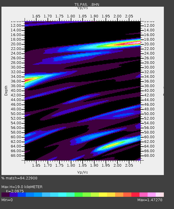
| Estimated Moho Depth: |
19.0 km |
| Estimated Crust Vp/Vs: |
2.10 |
| Assumed Crust Vp: |
6.1 km/s |
| Estimated Crust Vs: |
2.908 km/s |
| Estimated Crust Poisson's Ratio: |
0.35 |
|
| Radial Match: |
94.22908 % |
| Radial Bump: |
399 |
| Transverse Match: |
82.99876 % |
| Transverse Bump: |
395 |
| SOD ConfigId: |
4714 |
| Insert Time: |
2010-02-26 14:33:47.026 +0000 |
| GWidth: |
2.5 |
| Max Bumps: |
400 |
| Tol: |
0.001 |
|

Signal To Noise
| Channel | StoN | STA | LTA |
| TS:PAS: :BHN:20030121T02:52:42.848002Z | 1.8157077 | 3.8671627E-7 | 2.1298376E-7 |
| TS:PAS: :BHE:20030121T02:52:42.848002Z | 1.4262531 | 4.2447294E-7 | 2.9761404E-7 |
| TS:PAS: :BHZ:20030121T02:52:42.848002Z | 4.1711845 | 1.2491481E-6 | 2.9947083E-7 |
| Arrivals |
| Ps | 3.6 SECOND |
| PpPs | 9.1 SECOND |
| PsPs/PpSs | 13 SECOND |


