You are here: Home > Network List > TA - USArray Transportable Network (new EarthScope stations) Stations List
> Station W17A Winslow, AZ, USA > Earthquake Result Viewer
W17A Winslow, AZ, USA - Earthquake Result Viewer

| Earthquake location: |
Near Coast Of Northern Chile |
| Earthquake latitude/longitude: |
-22.9/-70.2 |
| Earthquake time(UTC): |
2007/11/15 (319) 15:05:58 GMT |
| Earthquake Depth: |
26 km |
| Earthquake Magnitude: |
6.1 MB, 6.6 MS, 6.8 MW, 6.6 MW |
| Earthquake Catalog/Contributor: |
WHDF/NEIC |
|
| Network: |
TA USArray Transportable Network (new EarthScope stations) |
| Station: |
W17A Winslow, AZ, USA |
| Lat/Lon: |
35.08 N/110.71 W |
| Elevation: |
1461 m |
|
| Distance: |
69.3 deg |
| Az: |
325.308 deg |
| Baz: |
140.223 deg |
| Ray Param: |
0.055709865 |
| Estimated Moho Depth: |
23.75 km |
| Estimated Crust Vp/Vs: |
1.60 |
| Assumed Crust Vp: |
6.207 km/s |
| Estimated Crust Vs: |
3.879 km/s |
| Estimated Crust Poisson's Ratio: |
0.18 |
|
| Radial Match: |
94.927734 % |
| Radial Bump: |
320 |
| Transverse Match: |
74.10896 % |
| Transverse Bump: |
400 |
| SOD ConfigId: |
2564 |
| Insert Time: |
2010-03-07 05:41:12.510 +0000 |
| GWidth: |
2.5 |
| Max Bumps: |
400 |
| Tol: |
0.001 |
|
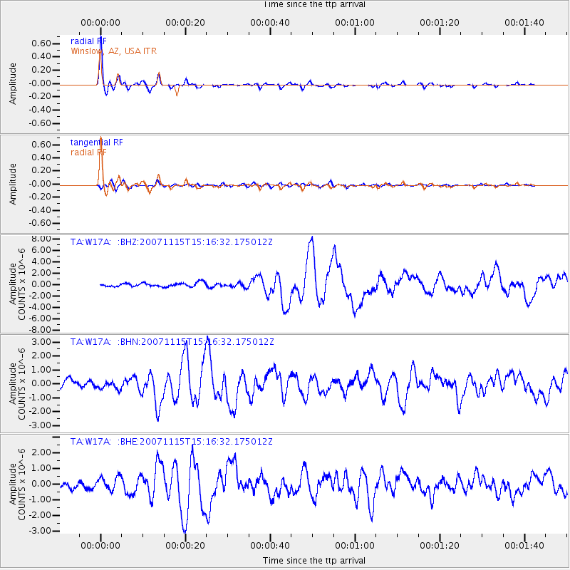
Signal To Noise
| Channel | StoN | STA | LTA |
| TA:W17A: :BHN:20071115T15:16:32.175012Z | 1.1670873 | 2.8439982E-7 | 2.4368342E-7 |
| TA:W17A: :BHE:20071115T15:16:32.175012Z | 2.1608198 | 4.5239992E-7 | 2.0936493E-7 |
| TA:W17A: :BHZ:20071115T15:16:32.175012Z | 1.1960843 | 3.8918157E-7 | 3.2537972E-7 |
| Arrivals |
| Ps | 2.4 SECOND |
| PpPs | 9.6 SECOND |
| PsPs/PpSs | 12 SECOND |


