You are here: Home > Network List > TA - USArray Transportable Network (new EarthScope stations) Stations List
> Station W17A Winslow, AZ, USA > Earthquake Result Viewer
W17A Winslow, AZ, USA - Earthquake Result Viewer
| Earthquake location: |
Northern Chile |
| Earthquake latitude/longitude: |
-22.2/-69.9 |
| Earthquake time(UTC): |
2007/11/14 (318) 15:40:50 GMT |
| Earthquake Depth: |
40 km |
| Earthquake Magnitude: |
6.7 MB, 7.4 MS, 7.7 MW, 7.4 ME |
| Earthquake Catalog/Contributor: |
WHDF/NEIC |
|
| Network: |
TA USArray Transportable Network (new EarthScope stations) |
| Station: |
W17A Winslow, AZ, USA |
| Lat/Lon: |
35.08 N/110.71 W |
| Elevation: |
1461 m |
|
| Distance: |
68.9 deg |
| Az: |
324.928 deg |
| Baz: |
139.529 deg |
| Ray Param: |
0.055917267 |
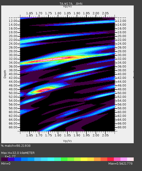
| Estimated Moho Depth: |
32.0 km |
| Estimated Crust Vp/Vs: |
1.77 |
| Assumed Crust Vp: |
6.207 km/s |
| Estimated Crust Vs: |
3.507 km/s |
| Estimated Crust Poisson's Ratio: |
0.27 |
|
| Radial Match: |
98.21938 % |
| Radial Bump: |
400 |
| Transverse Match: |
88.50295 % |
| Transverse Bump: |
400 |
| SOD ConfigId: |
2564 |
| Insert Time: |
2010-03-07 05:41:16.311 +0000 |
| GWidth: |
2.5 |
| Max Bumps: |
400 |
| Tol: |
0.001 |
|
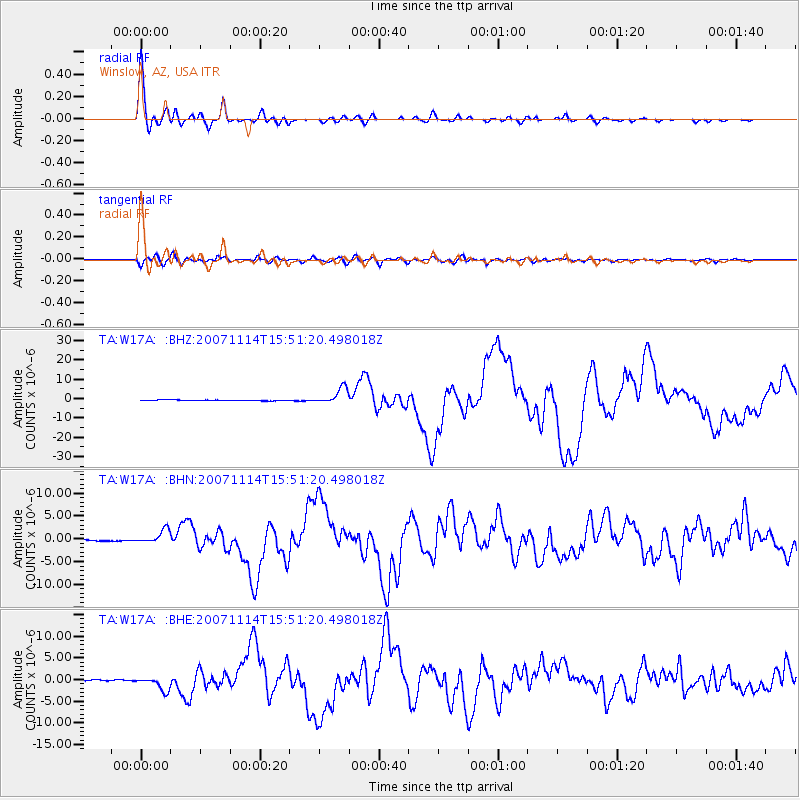
Signal To Noise
| Channel | StoN | STA | LTA |
| TA:W17A: :BHN:20071114T15:51:20.498018Z | 12.301637 | 1.519892E-6 | 1.2355201E-7 |
| TA:W17A: :BHE:20071114T15:51:20.498018Z | 11.52717 | 1.584477E-6 | 1.3745584E-7 |
| TA:W17A: :BHZ:20071114T15:51:20.498018Z | 21.27818 | 4.130653E-6 | 1.9412624E-7 |
| Arrivals |
| Ps | 4.1 SECOND |
| PpPs | 14 SECOND |
| PsPs/PpSs | 18 SECOND |


