W17A Winslow, AZ, USA - Earthquake Result Viewer
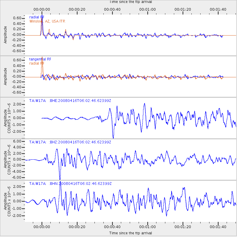
Earthquake location: Andreanof Islands, Aleutian Is.
Earthquake latitude/longitude: 51.9/-179.2
Earthquake time(UTC): 2008/04/16 (107) 05:54:19 GMT
Earthquake Depth: 13 km
Earthquake Magnitude: 6.1 MB, 6.5 MS, 6.6 MW, 6.6 MW
Earthquake Catalog/Contributor: WHDF/NEIC
Network: TA USArray Transportable Network (new EarthScope stations)
Station: W17A Winslow, AZ, USA
Lat/Lon: 35.08 N/110.71 W
Elevation: 1461 m
Distance: 50.5 deg
Az: 81.186 deg
Baz: 311.678 deg
Ray Param: 0.067986995
Estimated Moho Depth: 33.25 km
Estimated Crust Vp/Vs: 1.72
Assumed Crust Vp: 6.207 km/s
Estimated Crust Vs: 3.609 km/s
Estimated Crust Poisson's Ratio: 0.24
Radial Match: 95.60529 %
Radial Bump: 400
Transverse Match: 84.15067 %
Transverse Bump: 400
SOD ConfigId: 2504
Insert Time: 2010-03-07 05:42:11.747 +0000
GWidth: 2.5
Max Bumps: 400
Tol: 0.001

Signal To Noise

ChannelStoNSTALTA
TA:W17A: :BHZ:20080416T06:02:46.62399Z5.433436.875656E-71.2654357E-7
TA:W17A: :BHN:20080416T06:02:46.62399Z2.4580972.9241278E-71.1895901E-7
TA:W17A: :BHE:20080416T06:02:46.62399Z2.12411642.4176376E-71.1381851E-7
Arrivals
Ps4.1 SECOND
PpPs14 SECOND
PsPs/PpSs18 SECOND