You are here: Home > Network List > TA - USArray Transportable Network (new EarthScope stations) Stations List
> Station W17A Winslow, AZ, USA > Earthquake Result Viewer
W17A Winslow, AZ, USA - Earthquake Result Viewer
| Earthquake location: |
Iceland |
| Earthquake latitude/longitude: |
64.0/-21.0 |
| Earthquake time(UTC): |
2008/05/29 (150) 15:46:00 GMT |
| Earthquake Depth: |
10 km |
| Earthquake Magnitude: |
6.0 MB, 6.2 MS, 6.3 MW, 6.2 MW |
| Earthquake Catalog/Contributor: |
WHDF/NEIC |
|
| Network: |
TA USArray Transportable Network (new EarthScope stations) |
| Station: |
W17A Winslow, AZ, USA |
| Lat/Lon: |
35.08 N/110.71 W |
| Elevation: |
1461 m |
|
| Distance: |
59.0 deg |
| Az: |
286.842 deg |
| Baz: |
30.949 deg |
| Ray Param: |
0.06249628 |
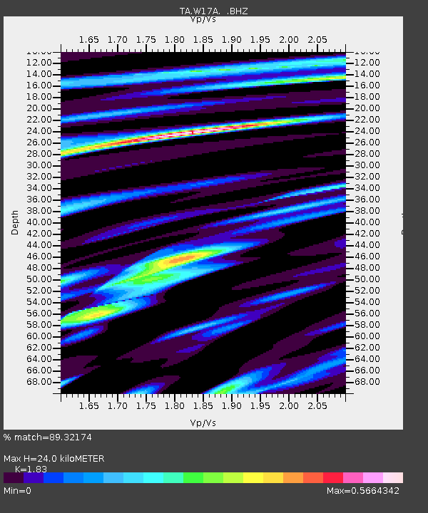
| Estimated Moho Depth: |
24.0 km |
| Estimated Crust Vp/Vs: |
1.83 |
| Assumed Crust Vp: |
6.207 km/s |
| Estimated Crust Vs: |
3.392 km/s |
| Estimated Crust Poisson's Ratio: |
0.29 |
|
| Radial Match: |
89.32174 % |
| Radial Bump: |
273 |
| Transverse Match: |
85.10845 % |
| Transverse Bump: |
377 |
| SOD ConfigId: |
2504 |
| Insert Time: |
2010-03-07 05:42:19.683 +0000 |
| GWidth: |
2.5 |
| Max Bumps: |
400 |
| Tol: |
0.001 |
|

Signal To Noise
| Channel | StoN | STA | LTA |
| TA:W17A: :BHZ:20080529T15:55:28.925017Z | 12.060278 | 7.9780176E-7 | 6.6151195E-8 |
| TA:W17A: :BHN:20080529T15:55:28.925017Z | 4.310703 | 3.1941337E-7 | 7.409775E-8 |
| TA:W17A: :BHE:20080529T15:55:28.925017Z | 3.8322003 | 2.602861E-7 | 6.7920794E-8 |
| Arrivals |
| Ps | 3.4 SECOND |
| PpPs | 10 SECOND |
| PsPs/PpSs | 14 SECOND |


