You are here: Home > Network List > GS - US Geological Survey Networks Stations List
> Station CA06 CA06, Randsburg Wash Rd. > Earthquake Result Viewer
CA06 CA06, Randsburg Wash Rd. - Earthquake Result Viewer
| Earthquake location: |
Fiji Islands Region |
| Earthquake latitude/longitude: |
-22.0/-179.5 |
| Earthquake time(UTC): |
2019/11/08 (312) 10:44:44 GMT |
| Earthquake Depth: |
583 km |
| Earthquake Magnitude: |
6.5 Mww |
| Earthquake Catalog/Contributor: |
NEIC PDE/us |
|
| Network: |
GS US Geological Survey Networks |
| Station: |
CA06 CA06, Randsburg Wash Rd. |
| Lat/Lon: |
35.60 N/117.49 W |
| Elevation: |
796 m |
|
| Distance: |
82.0 deg |
| Az: |
46.607 deg |
| Baz: |
235.863 deg |
| Ray Param: |
0.04546199 |
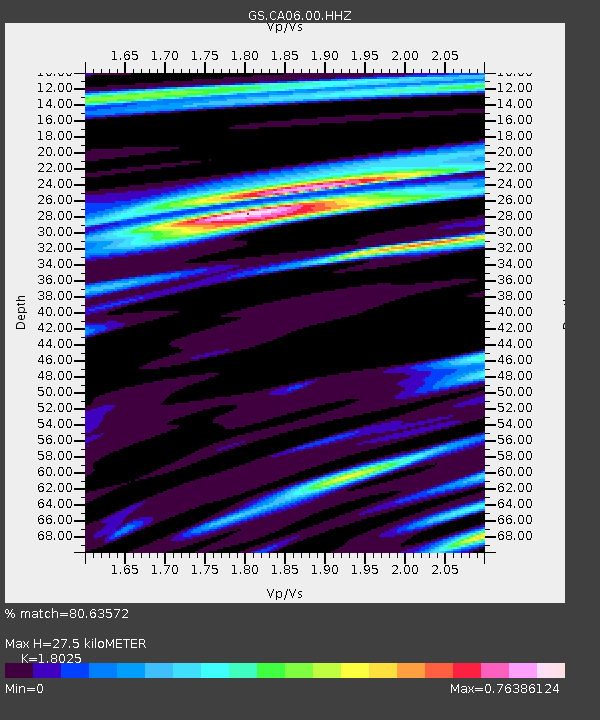
| Estimated Moho Depth: |
27.5 km |
| Estimated Crust Vp/Vs: |
1.80 |
| Assumed Crust Vp: |
6.276 km/s |
| Estimated Crust Vs: |
3.482 km/s |
| Estimated Crust Poisson's Ratio: |
0.28 |
|
| Radial Match: |
80.63572 % |
| Radial Bump: |
400 |
| Transverse Match: |
73.71976 % |
| Transverse Bump: |
400 |
| SOD ConfigId: |
19951751 |
| Insert Time: |
2019-11-22 10:52:44.208 +0000 |
| GWidth: |
2.5 |
| Max Bumps: |
400 |
| Tol: |
0.001 |
|

Signal To Noise
| Channel | StoN | STA | LTA |
| GS:CA06:00:HHZ:20191108T10:55:33.378991Z | 7.9297724 | 1.2043389E-6 | 1.518756E-7 |
| GS:CA06:00:HH1:20191108T10:55:33.378991Z | 3.5069716 | 2.548874E-7 | 7.2680194E-8 |
| GS:CA06:00:HH2:20191108T10:55:33.378991Z | 4.227837 | 4.2722843E-7 | 1.010513E-7 |
| Arrivals |
| Ps | 3.6 SECOND |
| PpPs | 12 SECOND |
| PsPs/PpSs | 16 SECOND |


