You are here: Home > Network List > TA - USArray Transportable Network (new EarthScope stations) Stations List
> Station W17A Winslow, AZ, USA > Earthquake Result Viewer
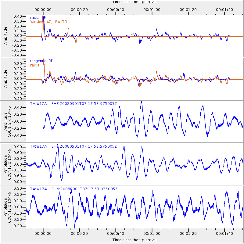
W17A Winslow, AZ, USA - Earthquake Result Viewer
*The percent match for this event was below the threshold and hence no stack was calculated.
| Earthquake location: |
Fiji Islands Region |
| Earthquake latitude/longitude: |
-15.3/-176.4 |
| Earthquake time(UTC): |
2008/09/01 (245) 07:06:16 GMT |
| Earthquake Depth: |
10 km |
| Earthquake Magnitude: |
5.6 MS, 5.4 MB, 5.7 MW, 5.7 MW |
| Earthquake Catalog/Contributor: |
WHDF/NEIC |
|
| Network: |
TA USArray Transportable Network (new EarthScope stations) |
| Station: |
W17A Winslow, AZ, USA |
| Lat/Lon: |
35.08 N/110.71 W |
| Elevation: |
1461 m |
|
| Distance: |
79.9 deg |
| Az: |
49.409 deg |
| Baz: |
243.334 deg |
| Ray Param: |
$rayparam |
*The percent match for this event was below the threshold and hence was not used in the summary stack. |
|
| Radial Match: |
49.516037 % |
| Radial Bump: |
394 |
| Transverse Match: |
54.679516 % |
| Transverse Bump: |
341 |
| SOD ConfigId: |
2504 |
| Insert Time: |
2010-03-07 05:42:57.012 +0000 |
| GWidth: |
2.5 |
| Max Bumps: |
400 |
| Tol: |
0.001 |
|
Signal To Noise
| Channel | StoN | STA | LTA |
| TA:W17A: :BHZ:20080901T07:17:53.975005Z | 1.9114394 | 2.6708364E-7 | 1.3972907E-7 |
| TA:W17A: :BHN:20080901T07:17:53.975005Z | 0.43079856 | 4.9095444E-8 | 1.1396381E-7 |
| TA:W17A: :BHE:20080901T07:17:53.975005Z | 0.8638892 | 8.8471594E-8 | 1.024108E-7 |
| Arrivals |
| Ps | |
| PpPs | |
| PsPs/PpSs | |


