You are here: Home > Network List > TA - USArray Transportable Network (new EarthScope stations) Stations List
> Station W17A Winslow, AZ, USA > Earthquake Result Viewer
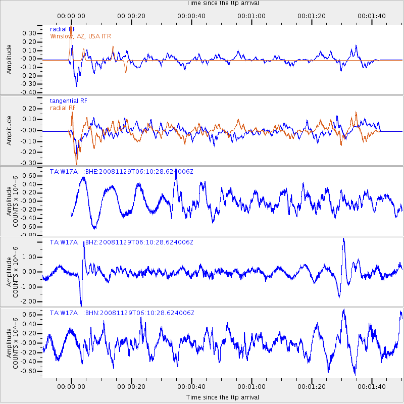
W17A Winslow, AZ, USA - Earthquake Result Viewer
*The percent match for this event was below the threshold and hence no stack was calculated.
| Earthquake location: |
Fiji Islands Region |
| Earthquake latitude/longitude: |
-18.7/-177.7 |
| Earthquake time(UTC): |
2008/11/29 (334) 05:59:16 GMT |
| Earthquake Depth: |
386 km |
| Earthquake Magnitude: |
5.7 MB, 6.0 MW, 5.9 MW |
| Earthquake Catalog/Contributor: |
WHDF/NEIC |
|
| Network: |
TA USArray Transportable Network (new EarthScope stations) |
| Station: |
W17A Winslow, AZ, USA |
| Lat/Lon: |
35.08 N/110.71 W |
| Elevation: |
1461 m |
|
| Distance: |
83.0 deg |
| Az: |
49.518 deg |
| Baz: |
241.525 deg |
| Ray Param: |
$rayparam |
*The percent match for this event was below the threshold and hence was not used in the summary stack. |
|
| Radial Match: |
69.42935 % |
| Radial Bump: |
400 |
| Transverse Match: |
60.470062 % |
| Transverse Bump: |
400 |
| SOD ConfigId: |
2658 |
| Insert Time: |
2010-03-07 05:43:02.067 +0000 |
| GWidth: |
2.5 |
| Max Bumps: |
400 |
| Tol: |
0.001 |
|
Signal To Noise
| Channel | StoN | STA | LTA |
| TA:W17A: :BHZ:20081129T06:10:28.624006Z | 3.957329 | 9.220735E-7 | 2.33004E-7 |
| TA:W17A: :BHN:20081129T06:10:28.624006Z | 0.8973607 | 2.0506891E-7 | 2.2852451E-7 |
| TA:W17A: :BHE:20081129T06:10:28.624006Z | 0.7012491 | 2.2713185E-7 | 3.238961E-7 |
| Arrivals |
| Ps | |
| PpPs | |
| PsPs/PpSs | |


