You are here: Home > Network List > TS - TERRAscope (Southern California Seismic Network) Stations List
> Station PAS Pasadena, California, USA > Earthquake Result Viewer
PAS Pasadena, California, USA - Earthquake Result Viewer

| Earthquake location: |
Alaska Peninsula |
| Earthquake latitude/longitude: |
58.8/-156.8 |
| Earthquake time(UTC): |
1990/05/01 (121) 16:12:22 GMT |
| Earthquake Depth: |
217 km |
| Earthquake Magnitude: |
6.1 MB, 6.3 UNKNOWN |
| Earthquake Catalog/Contributor: |
WHDF/NEIC |
|
| Network: |
TS TERRAscope (Southern California Seismic Network) |
| Station: |
PAS Pasadena, California, USA |
| Lat/Lon: |
34.15 N/118.17 W |
| Elevation: |
295 m |
|
| Distance: |
35.5 deg |
| Az: |
116.84 deg |
| Baz: |
325.964 deg |
| Ray Param: |
0.076375134 |
| Estimated Moho Depth: |
61.75 km |
| Estimated Crust Vp/Vs: |
1.97 |
| Assumed Crust Vp: |
6.1 km/s |
| Estimated Crust Vs: |
3.104 km/s |
| Estimated Crust Poisson's Ratio: |
0.33 |
|
| Radial Match: |
85.27429 % |
| Radial Bump: |
400 |
| Transverse Match: |
82.158226 % |
| Transverse Bump: |
400 |
| SOD ConfigId: |
16938 |
| Insert Time: |
2010-02-26 14:33:52.350 +0000 |
| GWidth: |
2.5 |
| Max Bumps: |
400 |
| Tol: |
0.001 |
|
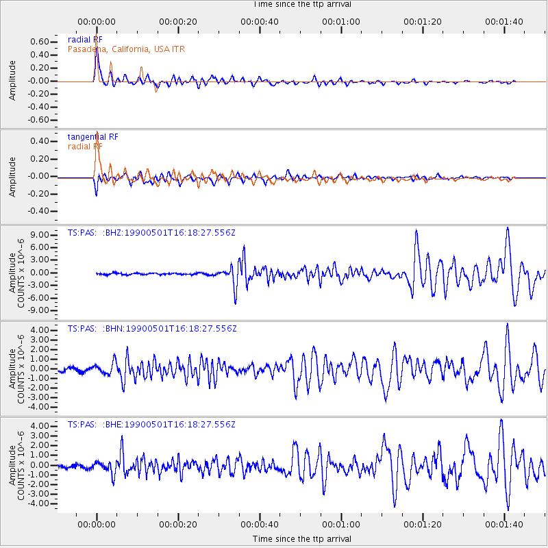
Signal To Noise
| Channel | StoN | STA | LTA |
| TS:PAS: :BHN:19900501T16:18:27.556Z | 4.1866274 | 6.110683E-7 | 1.4595716E-7 |
| TS:PAS: :BHE:19900501T16:18:27.556Z | 3.1828828 | 6.472897E-7 | 2.0336586E-7 |
| TS:PAS: :BHZ:19900501T16:18:27.556Z | 13.317084 | 2.322656E-6 | 1.7441175E-7 |
| Arrivals |
| Ps | 10 SECOND |
| PpPs | 28 SECOND |
| PsPs/PpSs | 39 SECOND |


