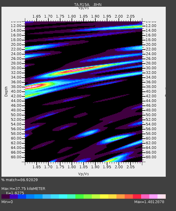
R15A Junction, UT, USA - Earthquake Result Viewer
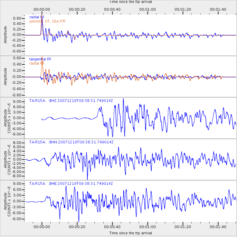
Earthquake location: Andreanof Islands, Aleutian Is.
Earthquake latitude/longitude: 51.4/-179.5
Earthquake time(UTC): 2007/12/19 (353) 09:30:27 GMT
Earthquake Depth: 29 km
Earthquake Magnitude: 6.4 MB, 7.1 MS, 7.1 MW, 7.0 MW
Earthquake Catalog/Contributor: WHDF/NEIC
Network: TA USArray Transportable Network (new EarthScope stations)
Station: R15A Junction, UT, USA
Lat/Lon: 38.21 N/112.28 W
Elevation: 1861 m
Distance: 47.9 deg
Az: 78.423 deg
Baz: 308.77 deg
Ray Param: 0.06967033
Estimated Moho Depth: 37.75 km
Estimated Crust Vp/Vs: 1.63
Assumed Crust Vp: 6.276 km/s
Estimated Crust Vs: 3.856 km/s
Estimated Crust Poisson's Ratio: 0.20
Radial Match: 86.92829 %
Radial Bump: 400
Transverse Match: 73.56796 %
Transverse Bump: 400
SOD ConfigId: 2564
Insert Time: 2010-03-07 05:44:10.339 +0000
GWidth: 2.5
Max Bumps: 400
Tol: 0.001

Signal To Noise

ChannelStoNSTALTA
TA:R15A: :BHN:20071219T09:38:31.749014Z4.0030891.4943474E-63.7329858E-7
TA:R15A: :BHE:20071219T09:38:31.749014Z4.2284391.5580563E-63.684708E-7
TA:R15A: :BHZ:20071219T09:38:31.749014Z8.5867883.207716E-63.7356412E-7
Arrivals
Ps4.0 SECOND
PpPs15 SECOND
PsPs/PpSs19 SECOND