You are here: Home > Network List > GS - US Geological Survey Networks Stations List
> Station KS21 NEIC Portable/Temp deployment > Earthquake Result Viewer
KS21 NEIC Portable/Temp deployment - Earthquake Result Viewer
| Earthquake location: |
Southern Alaska |
| Earthquake latitude/longitude: |
59.6/-152.6 |
| Earthquake time(UTC): |
2017/03/02 (061) 02:11:30 GMT |
| Earthquake Depth: |
77 km |
| Earthquake Magnitude: |
5.5 Ml |
| Earthquake Catalog/Contributor: |
NEIC PDE/ak |
|
| Network: |
GS US Geological Survey Networks |
| Station: |
KS21 NEIC Portable/Temp deployment |
| Lat/Lon: |
37.29 N/97.66 W |
| Elevation: |
414 m |
|
| Distance: |
41.2 deg |
| Az: |
97.628 deg |
| Baz: |
320.783 deg |
| Ray Param: |
0.073686846 |
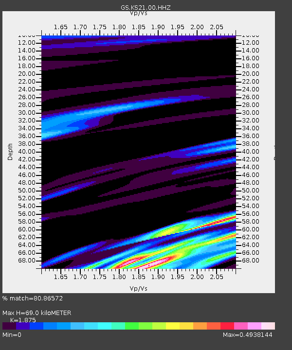
| Estimated Moho Depth: |
69.0 km |
| Estimated Crust Vp/Vs: |
1.88 |
| Assumed Crust Vp: |
6.483 km/s |
| Estimated Crust Vs: |
3.457 km/s |
| Estimated Crust Poisson's Ratio: |
0.30 |
|
| Radial Match: |
80.86572 % |
| Radial Bump: |
254 |
| Transverse Match: |
74.835884 % |
| Transverse Bump: |
370 |
| SOD ConfigId: |
1992691 |
| Insert Time: |
2017-03-16 02:13:10.153 +0000 |
| GWidth: |
2.5 |
| Max Bumps: |
400 |
| Tol: |
0.001 |
|

Signal To Noise
| Channel | StoN | STA | LTA |
| GS:KS21:00:HHZ:20170302T02:18:37.398997Z | 1.7465072 | 2.8616785E-7 | 1.6385151E-7 |
| GS:KS21:00:HH1:20170302T02:18:37.398997Z | 0.65674835 | 1.3152832E-7 | 2.0027201E-7 |
| GS:KS21:00:HH2:20170302T02:18:37.398997Z | 2.0057306 | 2.8738634E-7 | 1.4328262E-7 |
| Arrivals |
| Ps | 9.9 SECOND |
| PpPs | 29 SECOND |
| PsPs/PpSs | 39 SECOND |


