You are here: Home > Network List > TA - USArray Transportable Network (new EarthScope stations) Stations List
> Station R15A Junction, UT, USA > Earthquake Result Viewer
R15A Junction, UT, USA - Earthquake Result Viewer
| Earthquake location: |
Near Coast Of Peru |
| Earthquake latitude/longitude: |
-13.3/-76.5 |
| Earthquake time(UTC): |
2007/08/16 (228) 00:02:41 GMT |
| Earthquake Depth: |
40 km |
| Earthquake Magnitude: |
5.6 MB |
| Earthquake Catalog/Contributor: |
WHDF/NEIC |
|
| Network: |
TA USArray Transportable Network (new EarthScope stations) |
| Station: |
R15A Junction, UT, USA |
| Lat/Lon: |
38.21 N/112.28 W |
| Elevation: |
1861 m |
|
| Distance: |
61.2 deg |
| Az: |
328.283 deg |
| Baz: |
139.472 deg |
| Ray Param: |
0.06095662 |
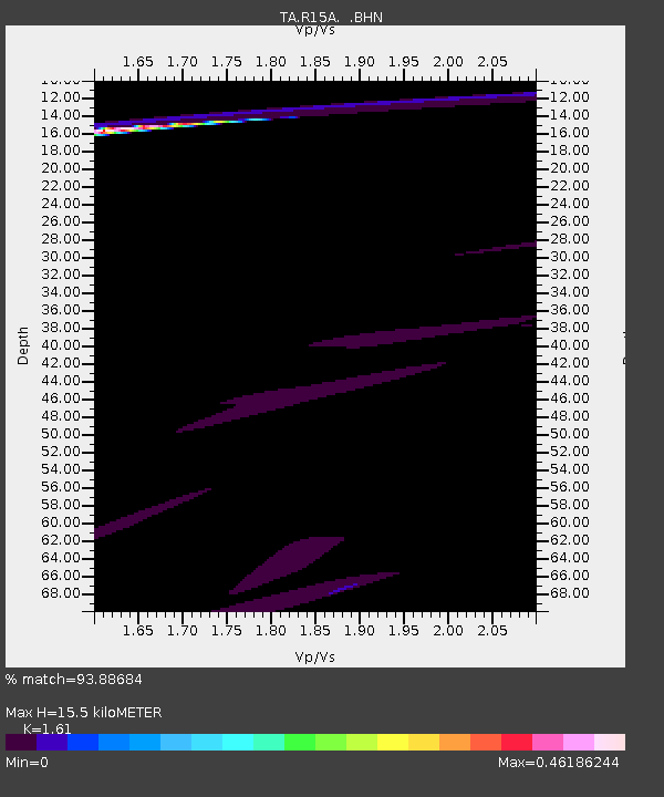
| Estimated Moho Depth: |
15.5 km |
| Estimated Crust Vp/Vs: |
1.61 |
| Assumed Crust Vp: |
6.276 km/s |
| Estimated Crust Vs: |
3.898 km/s |
| Estimated Crust Poisson's Ratio: |
0.19 |
|
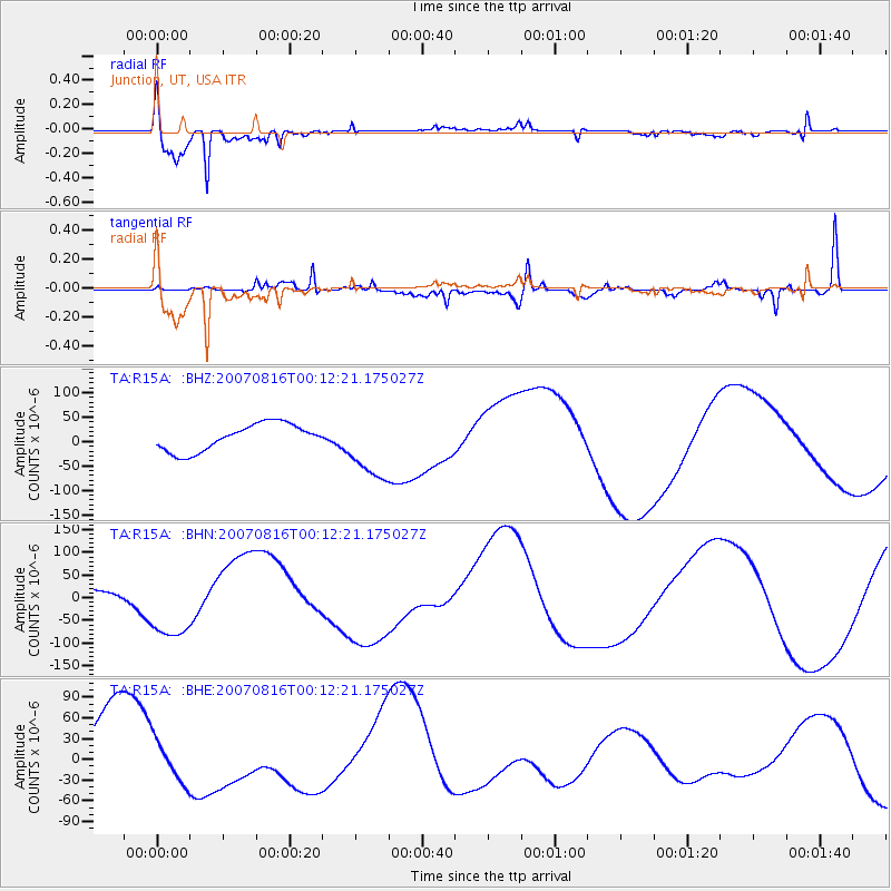
| Radial Match: |
93.88684 % |
| Radial Bump: |
339 |
| Transverse Match: |
73.46172 % |
| Transverse Bump: |
366 |
| SOD ConfigId: |
2564 |
| Insert Time: |
2010-03-07 05:44:31.182 +0000 |
| GWidth: |
2.5 |
| Max Bumps: |
400 |
| Tol: |
0.001 |
|
Signal To Noise
| Channel | StoN | STA | LTA |
| TA:R15A: :BHN:20070816T00:12:21.175027Z | 4.3529825 | 7.5147946E-5 | 1.7263552E-5 |
| TA:R15A: :BHE:20070816T00:12:21.175027Z | 0.60143495 | 2.9779285E-5 | 4.9513725E-5 |
| TA:R15A: :BHZ:20070816T00:12:21.175027Z | 2.542012 | 6.9818074E-5 | 2.7465674E-5 |
| Arrivals |
| Ps | 1.6 SECOND |
| PpPs | 6.1 SECOND |
| PsPs/PpSs | 7.7 SECOND |


