You are here: Home > Network List > TA - USArray Transportable Network (new EarthScope stations) Stations List
> Station R15A Junction, UT, USA > Earthquake Result Viewer
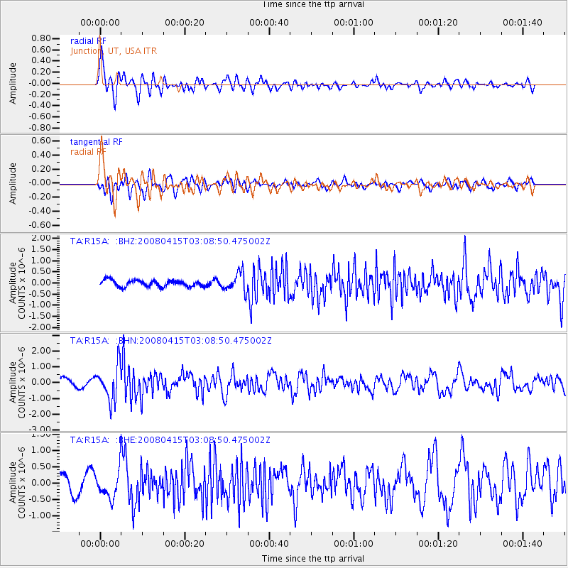
R15A Junction, UT, USA - Earthquake Result Viewer
*The percent match for this event was below the threshold and hence no stack was calculated.
| Earthquake location: |
Near Coast Of Guatemala |
| Earthquake latitude/longitude: |
13.6/-90.6 |
| Earthquake time(UTC): |
2008/04/15 (106) 03:03:04 GMT |
| Earthquake Depth: |
33 km |
| Earthquake Magnitude: |
5.6 MB, 5.8 MS, 6.1 MW, 6.1 MW |
| Earthquake Catalog/Contributor: |
WHDF/NEIC |
|
| Network: |
TA USArray Transportable Network (new EarthScope stations) |
| Station: |
R15A Junction, UT, USA |
| Lat/Lon: |
38.21 N/112.28 W |
| Elevation: |
1861 m |
|
| Distance: |
31.2 deg |
| Az: |
325.816 deg |
| Baz: |
136.085 deg |
| Ray Param: |
$rayparam |
*The percent match for this event was below the threshold and hence was not used in the summary stack. |
|
| Radial Match: |
73.207634 % |
| Radial Bump: |
400 |
| Transverse Match: |
64.20741 % |
| Transverse Bump: |
400 |
| SOD ConfigId: |
2504 |
| Insert Time: |
2010-03-07 05:45:06.668 +0000 |
| GWidth: |
2.5 |
| Max Bumps: |
400 |
| Tol: |
0.001 |
|
Signal To Noise
| Channel | StoN | STA | LTA |
| TA:R15A: :BHN:20080415T03:08:50.475002Z | 4.398118 | 1.1171779E-6 | 2.5401272E-7 |
| TA:R15A: :BHE:20080415T03:08:50.475002Z | 1.2543 | 4.2571446E-7 | 3.39404E-7 |
| TA:R15A: :BHZ:20080415T03:08:50.475002Z | 2.9645467 | 4.2689643E-7 | 1.4400058E-7 |
| Arrivals |
| Ps | |
| PpPs | |
| PsPs/PpSs | |


