You are here: Home > Network List > TS - TERRAscope (Southern California Seismic Network) Stations List
> Station PAS Pasadena, California, USA > Earthquake Result Viewer
PAS Pasadena, California, USA - Earthquake Result Viewer
| Earthquake location: |
South Of Panama |
| Earthquake latitude/longitude: |
7.0/-82.6 |
| Earthquake time(UTC): |
1990/05/08 (128) 00:01:39 GMT |
| Earthquake Depth: |
6.0 km |
| Earthquake Magnitude: |
6.3 MB, 6.3 MS, 6.5 UNKNOWN, 6.1 MD |
| Earthquake Catalog/Contributor: |
WHDF/NEIC |
|
| Network: |
TS TERRAscope (Southern California Seismic Network) |
| Station: |
PAS Pasadena, California, USA |
| Lat/Lon: |
34.15 N/118.17 W |
| Elevation: |
295 m |
|
| Distance: |
42.5 deg |
| Az: |
314.493 deg |
| Baz: |
121.362 deg |
| Ray Param: |
0.07314229 |
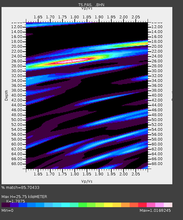
| Estimated Moho Depth: |
25.75 km |
| Estimated Crust Vp/Vs: |
1.79 |
| Assumed Crust Vp: |
6.1 km/s |
| Estimated Crust Vs: |
3.413 km/s |
| Estimated Crust Poisson's Ratio: |
0.27 |
|
| Radial Match: |
85.70433 % |
| Radial Bump: |
342 |
| Transverse Match: |
75.00912 % |
| Transverse Bump: |
400 |
| SOD ConfigId: |
16938 |
| Insert Time: |
2010-02-26 14:33:54.701 +0000 |
| GWidth: |
2.5 |
| Max Bumps: |
400 |
| Tol: |
0.001 |
|

Signal To Noise
| Channel | StoN | STA | LTA |
| TS:PAS: :BHN:19900508T00:09:04.813013Z | 1.4089073 | 3.544745E-7 | 2.5159534E-7 |
| TS:PAS: :BHE:19900508T00:09:04.813013Z | 1.8969734 | 8.0250993E-7 | 4.2304757E-7 |
| TS:PAS: :BHZ:19900508T00:09:04.813013Z | 4.8619843 | 1.976715E-6 | 4.0656548E-7 |
| Arrivals |
| Ps | 3.5 SECOND |
| PpPs | 11 SECOND |
| PsPs/PpSs | 15 SECOND |


