You are here: Home > Network List > US - United States National Seismic Network Stations List
> Station DGMT Dagmar, Montana, USA > Earthquake Result Viewer
DGMT Dagmar, Montana, USA - Earthquake Result Viewer
*The percent match for this event was below the threshold and hence no stack was calculated.
| Earthquake location: |
Guatemala |
| Earthquake latitude/longitude: |
14.5/-90.3 |
| Earthquake time(UTC): |
2019/11/09 (313) 08:32:52 GMT |
| Earthquake Depth: |
197 km |
| Earthquake Magnitude: |
5.6 Mww |
| Earthquake Catalog/Contributor: |
NEIC PDE/us |
|
| Network: |
US United States National Seismic Network |
| Station: |
DGMT Dagmar, Montana, USA |
| Lat/Lon: |
48.47 N/104.20 W |
| Elevation: |
0.0 m |
|
| Distance: |
35.8 deg |
| Az: |
344.128 deg |
| Baz: |
156.543 deg |
| Ray Param: |
$rayparam |
*The percent match for this event was below the threshold and hence was not used in the summary stack. |
|
| Radial Match: |
39.769188 % |
| Radial Bump: |
307 |
| Transverse Match: |
64.166336 % |
| Transverse Bump: |
400 |
| SOD ConfigId: |
19951751 |
| Insert Time: |
2019-11-23 08:42:27.524 +0000 |
| GWidth: |
2.5 |
| Max Bumps: |
400 |
| Tol: |
0.001 |
|
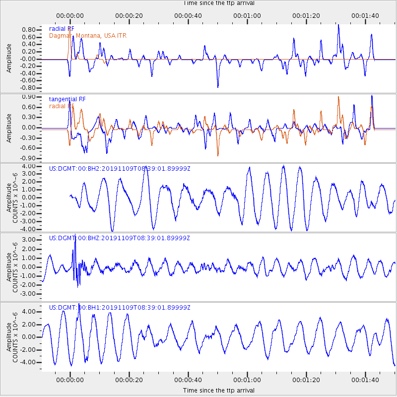
Signal To Noise
| Channel | StoN | STA | LTA |
| US:DGMT:00:BHZ:20191109T08:39:01.89999Z | 1.5067221 | 1.0825217E-6 | 7.184615E-7 |
| US:DGMT:00:BH1:20191109T08:39:01.89999Z | 1.9597223 | 2.8832753E-6 | 1.4712673E-6 |
| US:DGMT:00:BH2:20191109T08:39:01.89999Z | 0.8828616 | 1.3995844E-6 | 1.5852818E-6 |
| Arrivals |
| Ps | |
| PpPs | |
| PsPs/PpSs | |


