You are here: Home > Network List > US - United States National Seismic Network Stations List
> Station AGMN Agassiz National Wildlife Refuge, Minnesota, USA > Earthquake Result Viewer
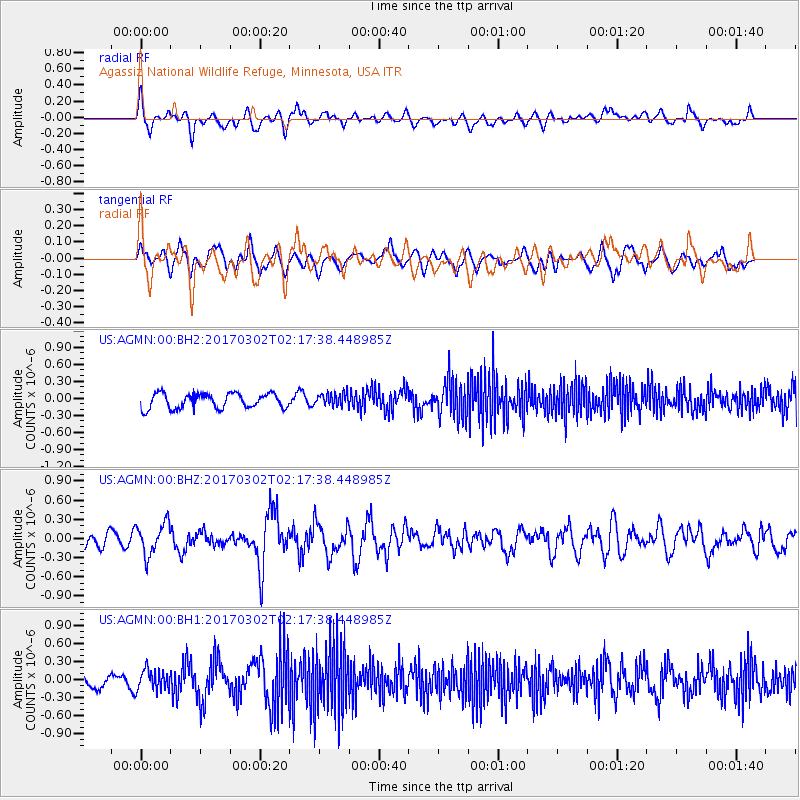
AGMN Agassiz National Wildlife Refuge, Minnesota, USA - Earthquake Result Viewer
*The percent match for this event was below the threshold and hence no stack was calculated.
| Earthquake location: |
Southern Alaska |
| Earthquake latitude/longitude: |
59.6/-152.6 |
| Earthquake time(UTC): |
2017/03/02 (061) 02:11:30 GMT |
| Earthquake Depth: |
77 km |
| Earthquake Magnitude: |
5.5 Ml |
| Earthquake Catalog/Contributor: |
NEIC PDE/ak |
|
| Network: |
US United States National Seismic Network |
| Station: |
AGMN Agassiz National Wildlife Refuge, Minnesota, USA |
| Lat/Lon: |
48.30 N/95.86 W |
| Elevation: |
351 m |
|
| Distance: |
34.2 deg |
| Az: |
83.51 deg |
| Baz: |
310.796 deg |
| Ray Param: |
$rayparam |
*The percent match for this event was below the threshold and hence was not used in the summary stack. |
|
| Radial Match: |
63.878914 % |
| Radial Bump: |
400 |
| Transverse Match: |
46.61808 % |
| Transverse Bump: |
400 |
| SOD ConfigId: |
1992691 |
| Insert Time: |
2017-03-16 02:15:17.758 +0000 |
| GWidth: |
2.5 |
| Max Bumps: |
400 |
| Tol: |
0.001 |
|
Signal To Noise
| Channel | StoN | STA | LTA |
| US:AGMN:00:BHZ:20170302T02:17:38.448985Z | 1.8564523 | 2.4592535E-7 | 1.324706E-7 |
| US:AGMN:00:BH1:20170302T02:17:38.448985Z | 1.3760982 | 1.7004373E-7 | 1.2356948E-7 |
| US:AGMN:00:BH2:20170302T02:17:38.448985Z | 0.84175074 | 1.1078024E-7 | 1.3160694E-7 |
| Arrivals |
| Ps | |
| PpPs | |
| PsPs/PpSs | |


