You are here: Home > Network List > TA - USArray Transportable Network (new EarthScope stations) Stations List
> Station R15A Junction, UT, USA > Earthquake Result Viewer
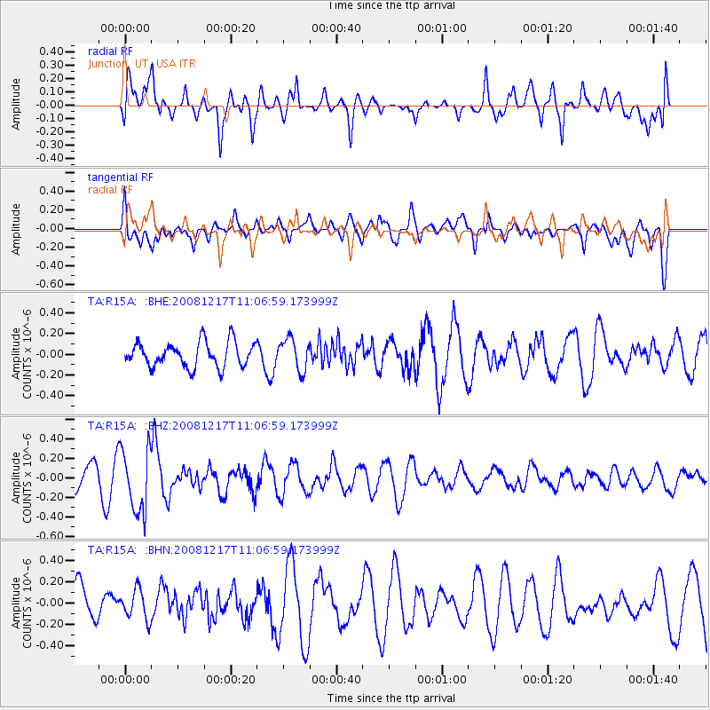
R15A Junction, UT, USA - Earthquake Result Viewer
*The percent match for this event was below the threshold and hence no stack was calculated.
| Earthquake location: |
Fiji Islands Region |
| Earthquake latitude/longitude: |
-17.7/-178.4 |
| Earthquake time(UTC): |
2008/12/17 (352) 10:55:59 GMT |
| Earthquake Depth: |
530 km |
| Earthquake Magnitude: |
5.8 MW, 5.2 MB, 5.8 MW |
| Earthquake Catalog/Contributor: |
WHDF/NEIC |
|
| Network: |
TA USArray Transportable Network (new EarthScope stations) |
| Station: |
R15A Junction, UT, USA |
| Lat/Lon: |
38.21 N/112.28 W |
| Elevation: |
1861 m |
|
| Distance: |
83.2 deg |
| Az: |
46.486 deg |
| Baz: |
241.325 deg |
| Ray Param: |
$rayparam |
*The percent match for this event was below the threshold and hence was not used in the summary stack. |
|
| Radial Match: |
57.470528 % |
| Radial Bump: |
400 |
| Transverse Match: |
56.538883 % |
| Transverse Bump: |
400 |
| SOD ConfigId: |
2658 |
| Insert Time: |
2010-03-07 05:45:43.604 +0000 |
| GWidth: |
2.5 |
| Max Bumps: |
400 |
| Tol: |
0.001 |
|
Signal To Noise
| Channel | StoN | STA | LTA |
| TA:R15A: :BHZ:20081217T11:06:59.173999Z | 1.9639333 | 3.2120946E-7 | 1.6355415E-7 |
| TA:R15A: :BHN:20081217T11:06:59.173999Z | 0.94520736 | 1.4411418E-7 | 1.5246833E-7 |
| TA:R15A: :BHE:20081217T11:06:59.173999Z | 1.2823331 | 1.5453644E-7 | 1.2051193E-7 |
| Arrivals |
| Ps | |
| PpPs | |
| PsPs/PpSs | |


