You are here: Home > Network List > TA - USArray Transportable Network (new EarthScope stations) Stations List
> Station R15A Junction, UT, USA > Earthquake Result Viewer
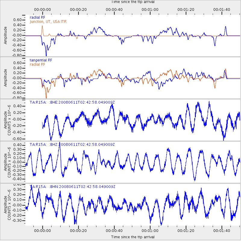
R15A Junction, UT, USA - Earthquake Result Viewer
*The percent match for this event was below the threshold and hence no stack was calculated.
| Earthquake location: |
South Of Kermadec Islands |
| Earthquake latitude/longitude: |
-33.4/179.9 |
| Earthquake time(UTC): |
2008/06/11 (163) 02:30:08 GMT |
| Earthquake Depth: |
22 km |
| Earthquake Magnitude: |
5.6 MB, 5.1 MS, 5.7 MW, 5.5 MW |
| Earthquake Catalog/Contributor: |
WHDF/NEIC |
|
| Network: |
TA USArray Transportable Network (new EarthScope stations) |
| Station: |
R15A Junction, UT, USA |
| Lat/Lon: |
38.21 N/112.28 W |
| Elevation: |
1861 m |
|
| Distance: |
95.1 deg |
| Az: |
47.08 deg |
| Baz: |
231.046 deg |
| Ray Param: |
$rayparam |
*The percent match for this event was below the threshold and hence was not used in the summary stack. |
|
| Radial Match: |
49.520905 % |
| Radial Bump: |
400 |
| Transverse Match: |
46.593624 % |
| Transverse Bump: |
400 |
| SOD ConfigId: |
2504 |
| Insert Time: |
2010-03-07 05:45:55.861 +0000 |
| GWidth: |
2.5 |
| Max Bumps: |
400 |
| Tol: |
0.001 |
|
Signal To Noise
| Channel | StoN | STA | LTA |
| TA:R15A: :BHZ:20080611T02:42:58.049009Z | 1.2534785 | 1.4025673E-7 | 1.1189401E-7 |
| TA:R15A: :BHN:20080611T02:42:58.049009Z | 0.7069723 | 1.9914135E-7 | 2.8168196E-7 |
| TA:R15A: :BHE:20080611T02:42:58.049009Z | 1.061301 | 2.2345044E-7 | 2.1054389E-7 |
| Arrivals |
| Ps | |
| PpPs | |
| PsPs/PpSs | |


