You are here: Home > Network List > GS - US Geological Survey Networks Stations List
> Station KAN13 Rinehart Farm > Earthquake Result Viewer
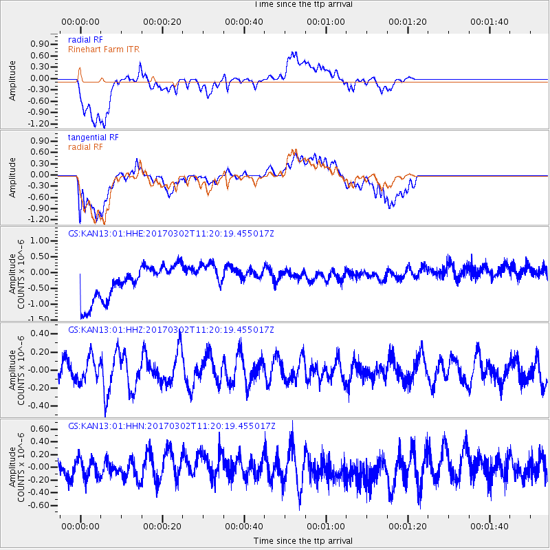
KAN13 Rinehart Farm - Earthquake Result Viewer
*The percent match for this event was below the threshold and hence no stack was calculated.
| Earthquake location: |
Turkey |
| Earthquake latitude/longitude: |
37.6/38.4 |
| Earthquake time(UTC): |
2017/03/02 (061) 11:07:27 GMT |
| Earthquake Depth: |
10 km |
| Earthquake Magnitude: |
5.6 Mww |
| Earthquake Catalog/Contributor: |
NEIC PDE/us |
|
| Network: |
GS US Geological Survey Networks |
| Station: |
KAN13 Rinehart Farm |
| Lat/Lon: |
37.01 N/97.48 W |
| Elevation: |
340 m |
|
| Distance: |
95.3 deg |
| Az: |
325.995 deg |
| Baz: |
33.718 deg |
| Ray Param: |
$rayparam |
*The percent match for this event was below the threshold and hence was not used in the summary stack. |
|
| Radial Match: |
63.57967 % |
| Radial Bump: |
400 |
| Transverse Match: |
50.77231 % |
| Transverse Bump: |
400 |
| SOD ConfigId: |
1992691 |
| Insert Time: |
2017-03-16 11:10:56.716 +0000 |
| GWidth: |
2.5 |
| Max Bumps: |
400 |
| Tol: |
0.001 |
|
Signal To Noise
| Channel | StoN | STA | LTA |
| GS:KAN13:01:HHZ:20170302T11:20:19.455017Z | 0.83574307 | 1.3365542E-7 | 1.5992406E-7 |
| GS:KAN13:01:HHN:20170302T11:20:19.455017Z | 0.9388676 | 1.56987E-7 | 1.6720887E-7 |
| GS:KAN13:01:HHE:20170302T11:20:19.455017Z | 0.9342427 | 4.985506E-7 | 5.336414E-7 |
| Arrivals |
| Ps | |
| PpPs | |
| PsPs/PpSs | |


