You are here: Home > Network List > TA - USArray Transportable Network (new EarthScope stations) Stations List
> Station R15A Junction, UT, USA > Earthquake Result Viewer
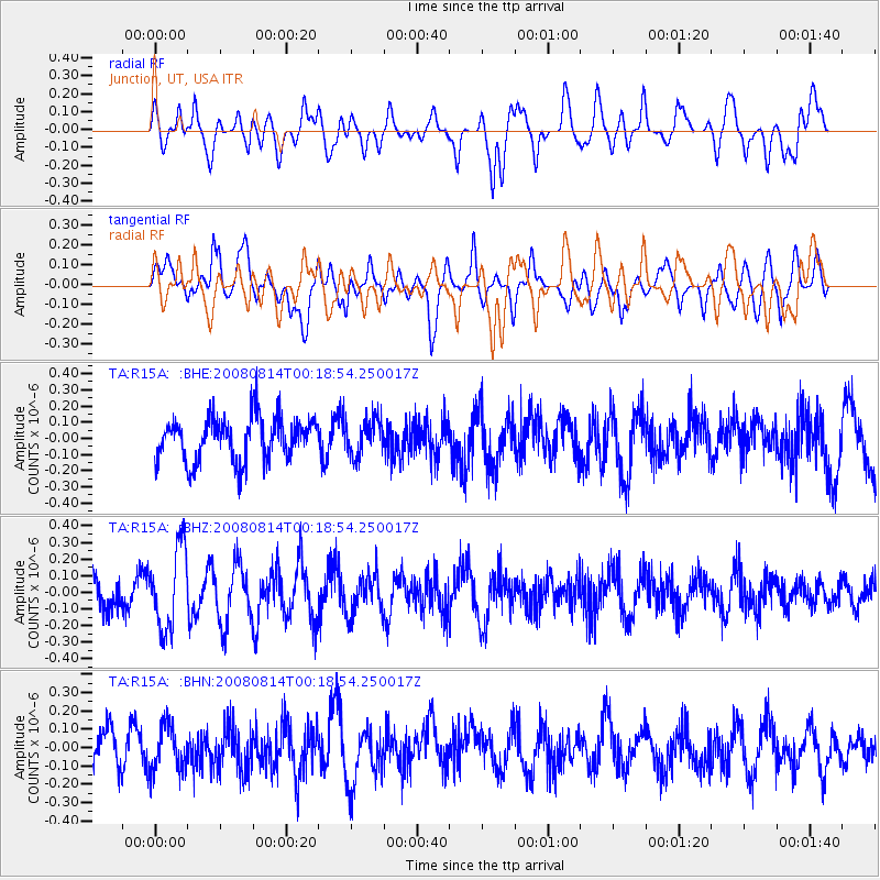
R15A Junction, UT, USA - Earthquake Result Viewer
*The percent match for this event was below the threshold and hence no stack was calculated.
| Earthquake location: |
Mariana Islands |
| Earthquake latitude/longitude: |
16.4/146.9 |
| Earthquake time(UTC): |
2008/08/14 (227) 00:06:40 GMT |
| Earthquake Depth: |
53 km |
| Earthquake Magnitude: |
5.5 MB, 4.8 MS |
| Earthquake Catalog/Contributor: |
WHDF/NEIC |
|
| Network: |
TA USArray Transportable Network (new EarthScope stations) |
| Station: |
R15A Junction, UT, USA |
| Lat/Lon: |
38.21 N/112.28 W |
| Elevation: |
1861 m |
|
| Distance: |
88.2 deg |
| Az: |
50.733 deg |
| Baz: |
289.41 deg |
| Ray Param: |
$rayparam |
*The percent match for this event was below the threshold and hence was not used in the summary stack. |
|
| Radial Match: |
43.830925 % |
| Radial Bump: |
400 |
| Transverse Match: |
56.131397 % |
| Transverse Bump: |
400 |
| SOD ConfigId: |
2504 |
| Insert Time: |
2010-03-07 05:46:04.878 +0000 |
| GWidth: |
2.5 |
| Max Bumps: |
400 |
| Tol: |
0.001 |
|
Signal To Noise
| Channel | StoN | STA | LTA |
| TA:R15A: :BHZ:20080814T00:18:54.250017Z | 2.0770366 | 2.4310586E-7 | 1.1704456E-7 |
| TA:R15A: :BHN:20080814T00:18:54.250017Z | 1.0206605 | 1.2633768E-7 | 1.2378032E-7 |
| TA:R15A: :BHE:20080814T00:18:54.250017Z | 0.8285341 | 1.115578E-7 | 1.346448E-7 |
| Arrivals |
| Ps | |
| PpPs | |
| PsPs/PpSs | |


