You are here: Home > Network List > TA - USArray Transportable Network (new EarthScope stations) Stations List
> Station R15A Junction, UT, USA > Earthquake Result Viewer
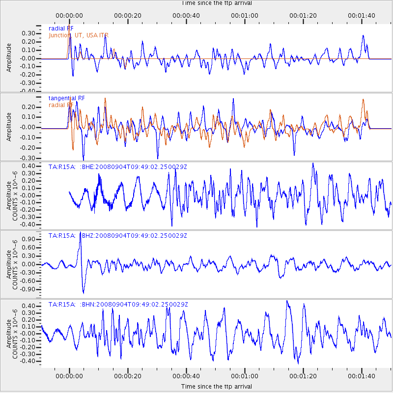
R15A Junction, UT, USA - Earthquake Result Viewer
*The percent match for this event was below the threshold and hence no stack was calculated.
| Earthquake location: |
Santa Cruz Islands |
| Earthquake latitude/longitude: |
-12.1/167.1 |
| Earthquake time(UTC): |
2008/09/04 (248) 09:37:03 GMT |
| Earthquake Depth: |
272 km |
| Earthquake Magnitude: |
5.5 MB, 5.7 MW, 5.6 MW |
| Earthquake Catalog/Contributor: |
WHDF/NEIC |
|
| Network: |
TA USArray Transportable Network (new EarthScope stations) |
| Station: |
R15A Junction, UT, USA |
| Lat/Lon: |
38.21 N/112.28 W |
| Elevation: |
1861 m |
|
| Distance: |
90.2 deg |
| Az: |
51.008 deg |
| Baz: |
254.764 deg |
| Ray Param: |
$rayparam |
*The percent match for this event was below the threshold and hence was not used in the summary stack. |
|
| Radial Match: |
64.42165 % |
| Radial Bump: |
400 |
| Transverse Match: |
67.93907 % |
| Transverse Bump: |
400 |
| SOD ConfigId: |
2504 |
| Insert Time: |
2010-03-07 05:46:06.935 +0000 |
| GWidth: |
2.5 |
| Max Bumps: |
400 |
| Tol: |
0.001 |
|
Signal To Noise
| Channel | StoN | STA | LTA |
| TA:R15A: :BHZ:20080904T09:49:02.250029Z | 3.0805662 | 4.517274E-7 | 1.4663779E-7 |
| TA:R15A: :BHN:20080904T09:49:02.250029Z | 1.5129862 | 1.16443125E-7 | 7.696245E-8 |
| TA:R15A: :BHE:20080904T09:49:02.250029Z | 1.1559076 | 1.3979418E-7 | 1.2093889E-7 |
| Arrivals |
| Ps | |
| PpPs | |
| PsPs/PpSs | |


