You are here: Home > Network List > IU - Global Seismograph Network (GSN - IRIS/USGS) Stations List
> Station RSSD Black Hills, South Dakota, USA > Earthquake Result Viewer
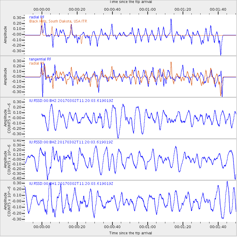
RSSD Black Hills, South Dakota, USA - Earthquake Result Viewer
*The percent match for this event was below the threshold and hence no stack was calculated.
| Earthquake location: |
Turkey |
| Earthquake latitude/longitude: |
37.6/38.4 |
| Earthquake time(UTC): |
2017/03/02 (061) 11:07:27 GMT |
| Earthquake Depth: |
10 km |
| Earthquake Magnitude: |
5.6 Mww |
| Earthquake Catalog/Contributor: |
NEIC PDE/us |
|
| Network: |
IU Global Seismograph Network (GSN - IRIS/USGS) |
| Station: |
RSSD Black Hills, South Dakota, USA |
| Lat/Lon: |
44.12 N/104.04 W |
| Elevation: |
2090 m |
|
| Distance: |
91.9 deg |
| Az: |
333.966 deg |
| Baz: |
28.958 deg |
| Ray Param: |
$rayparam |
*The percent match for this event was below the threshold and hence was not used in the summary stack. |
|
| Radial Match: |
57.731037 % |
| Radial Bump: |
341 |
| Transverse Match: |
59.990444 % |
| Transverse Bump: |
400 |
| SOD ConfigId: |
1992691 |
| Insert Time: |
2017-03-16 11:11:44.656 +0000 |
| GWidth: |
2.5 |
| Max Bumps: |
400 |
| Tol: |
0.001 |
|
Signal To Noise
| Channel | StoN | STA | LTA |
| IU:RSSD:00:BHZ:20170302T11:20:03.619019Z | 2.7892647 | 2.1526316E-7 | 7.71756E-8 |
| IU:RSSD:00:BH1:20170302T11:20:03.619019Z | 1.3938671 | 1.4605811E-7 | 1.04786245E-7 |
| IU:RSSD:00:BH2:20170302T11:20:03.619019Z | 0.7289157 | 8.035377E-8 | 1.102374E-7 |
| Arrivals |
| Ps | |
| PpPs | |
| PsPs/PpSs | |


